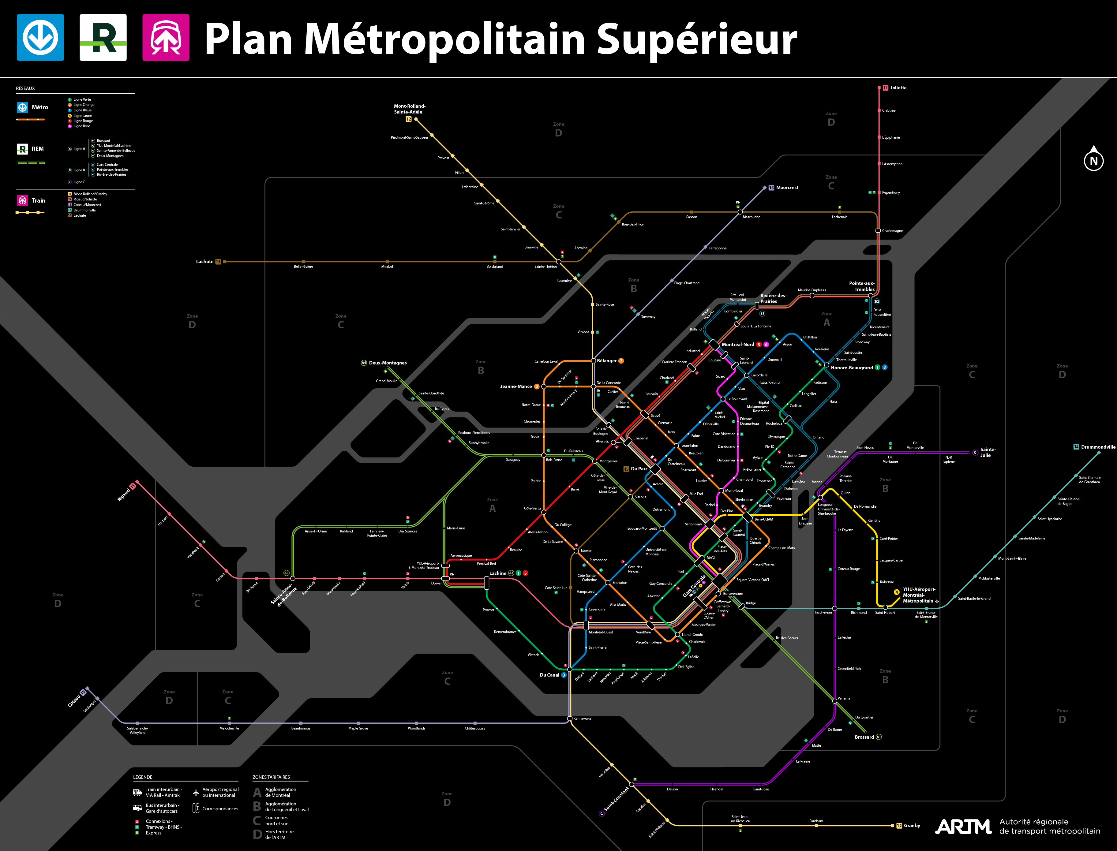
There’s a lot of things that I like on this map, but there’s places where I wonder if that plan is technically possible. The mess of lines that you’ve got going through Gare Centrale is what concerns me most. There’s no way that you are getting both a metro line and a train station in the space bellow René-Lévesque. That implies that the only viable option for your metro station is the original CDPQ viaduct plan.
I’m also concerned about the idea of splitting the orange line. It was mentioned more than a decade ago, but I have not heard anything about that since. I just don’t know how that would work given just how densely built up that area already is. I honestly think that we might as well just leave that one alone unless there is another branch somewhere that could be built to better serve the population.
Très interessant et super beau. Mais est-ce que je peux proposer qu’on ne met pas le logo officiel ARTM sur ces plans proposés? Des fois ils se mettent à circuler et ça passe pour du officiel.
Ironiquement, c’est exactement comme ça qu’est née la carte diagrammatique qui est maintenant la manière standard de cartographier un réseau de métro. La carte non-officielle du métro de Londres était plus pratique et plus facile à lire que la carte officielle. Le fait qu’on a un phénomène similaire indique clairement que l’ARTM a encore de la job a faire.
So the REM B I imagine making a small cut and cover tunnel on René-Lévesque and put the station East of the corner of Robert-Bourassa. Since the train would be automated, you don’t need a back station so you have enough room to put the yellow line on the right of way of Robert-Bourassa that I imagined in single track since McGill and would be built with a TBM. The train line would be under the current tracks of Gare Centrale built with a deep TBM with a station at the level of Mansfield allowing to not have two station on one another.
Yeah I know, although to mitigate the inconvenients of splitting the line, I imagined automating the line so removing the need of a back station and transforming Bonaventure in an island station. So train could go into station and directly go back allowing also a cross platform transfer with the two line avoiding the current stairs.
For the splitting, I don’t know if it is still a necessity, but without information that suggest the contrary I took for granted that it would have been necessary, at worst, imagine that it still one line because we don’t really know at this point if they would feel the need to split.
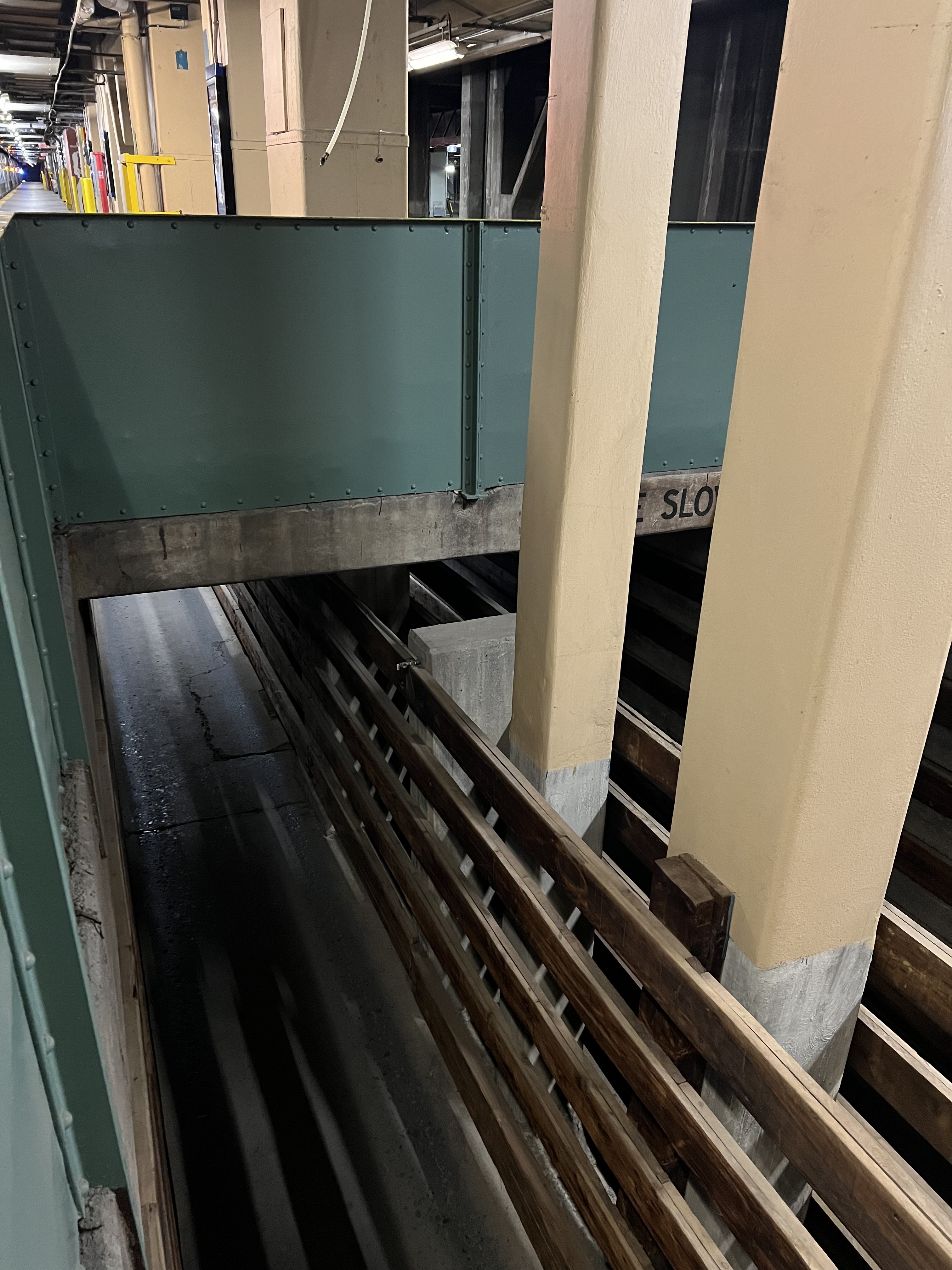
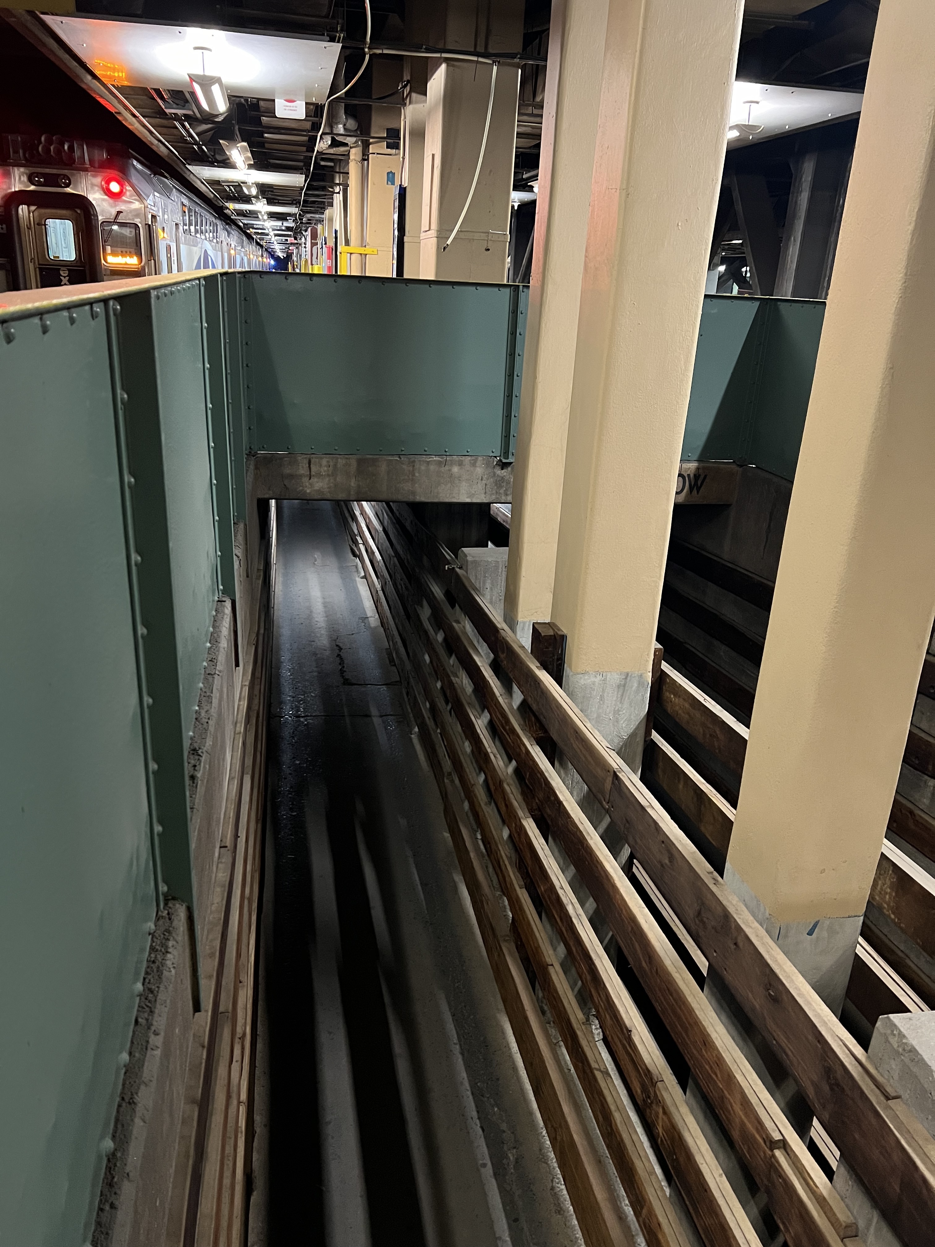
I don’t think you realise just how deep such a tunnnel would need to be. There’s a rather steep terrain drop between Saint-Antoine and René-Lévesque. By the time you get to René-Lévesque, the train tracks are already at least 15 meters bellow ground. There’s another old mostly abandoned level bellow that which was once used to move various farm animals.
As far as I’m aware, the general rule for tunnels is that they need at least as much cover as their diameter. So, if you’ve got a 10 meter tunnel, that means that it needs another 10 meters of ground above it. The station itself needs corridors to connect to it. That theatrically puts that station at about 40~45 meters underground. Access would be extremely difficult, and that’s just not practical considering how many peoples would use such a station.
When I put a station there on my map, its always a station that is directly under the existing terminal, and which is dug the same way that the new concourse was dug in Toronto. I beleive that it is the most reasonable solution. In other words, I’m talking about digging an access shaft nearby, propping up the pillars and then digging under the station. We’re talking about a project that would take at least 5 years to complete, but then again, nothing is going to be quick and easy near Gare Centrale.
With this depth, indeed, it would just be better to put the new station at the level of René-Lévesque perpendicular to the current platforms. Personnally, I think that with the TGV, the current central station would be saturated pretty soon so using it to start a new tunnel would have created a major chockpoint and since the third phase it’s for 2060 I gave me some slack. However, with the number of lines that I put on my plan, I’m not sure that the ridership would be actually that low especially if you take the entire complex into account. You sure for the diameter rule because the REM tunnel is pretty close to the green line one so maybe it’s not always the case when it come to station? We can also use the old abandonned level to do the beginning of a station box like the REM could have used at the airport. The tunnel then can be do with a TBM that I would personnally start to insert into the ground at Atwater, it would be already deep thought because I would start to do cut and cover before at the highway 15. So the terrain is not really a problem since I’m the other side of the highway and you have a good 1,6 km before the central station.
I would love a 3D model of everything going on around/under the PVM/QE Hotel/Gare centrale/LIVESTOCK TUNNEL/Place Bonaventure/Station Bonaventure/Autoroute Ville-Marie complex. It boggles the mind.
Vraiment malade cette carte! Il y a beaucoup de trucs que j’aime bien et j’apprécie le réseau que tu as prévu pour la Rive-sud, c’est exactement ce que ça prend.
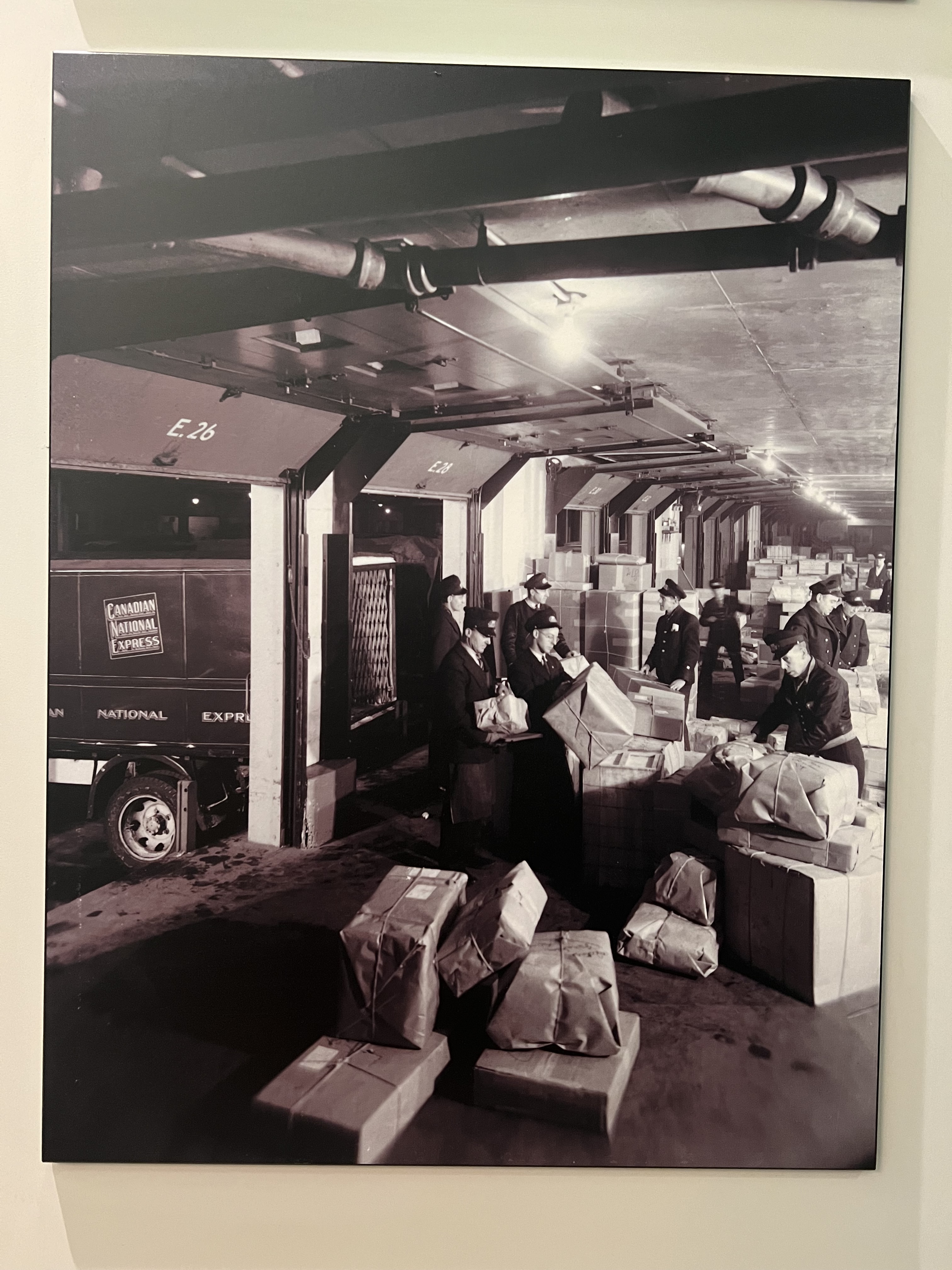
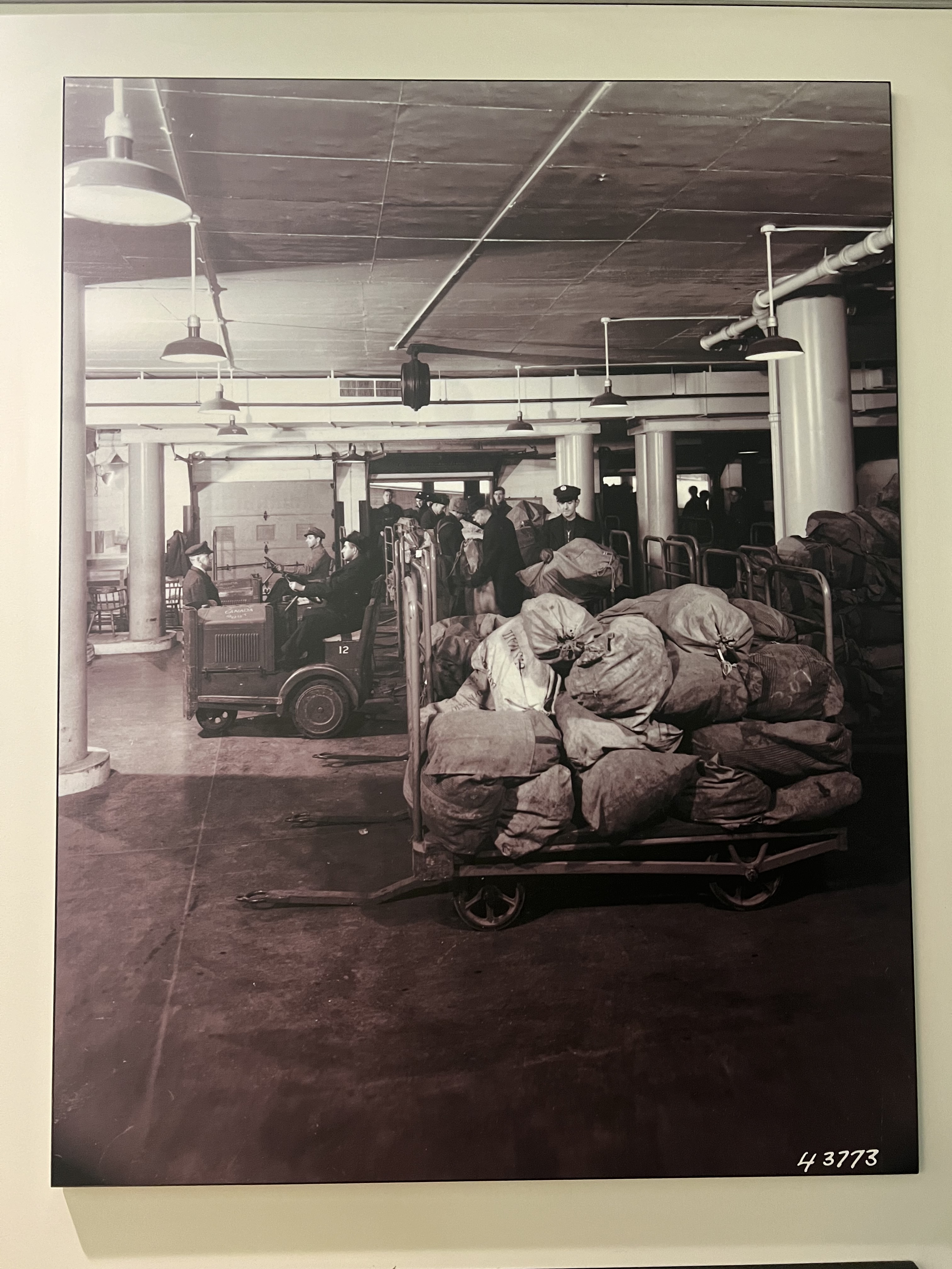
I’ve only heard it mentioned a few times. The only photo that I ever remember seeing is of a narrow wooden raceway used to direct animals. We likely aren’t talking about an entire level, but just a few small, rather narrow low ceiling corridors. Its likely that only one or two platforms were ever used for this purpose. I also remember that it was mentioned that theses remains had historical protection. There doesn’t seem to be much of any mention anywhere on the web, so I’m also at a bit of a loss for details here.
Edit: Here it is. I think that this is the photo that I saw.
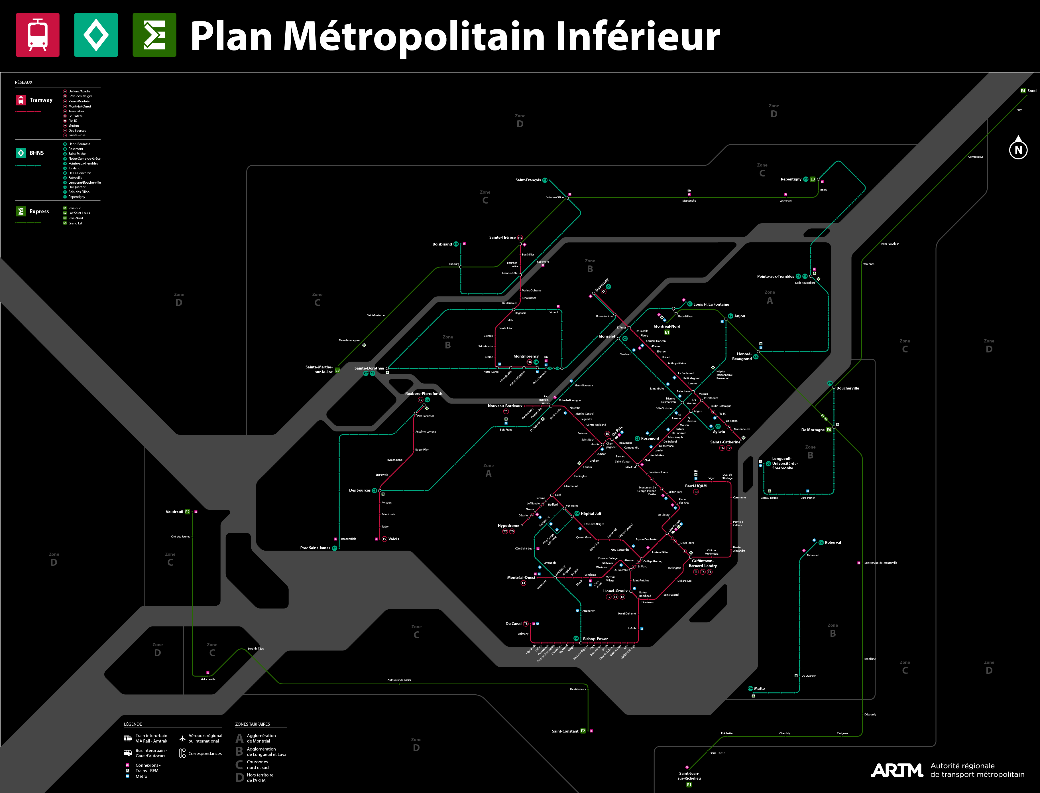
Qu’est-ce que tu emprunterais le plus si on avait ce réseau sur la Rive-Sud? Prends en considération que les trains je les upgrade en quelque chose comme un s-bahn donc des fréquences max de vingt minutes.
Whoa, I totally misunderstood. I thought we were saying that there was a tunnel independent of the train station, like predating Central Station. Oops.
Dans ce cas je prendrais la station Jacques-Cartier de la ligne jaune, pour aller prendre le train à St-Hubert pour ensuite sortir à la Gare Centrale, les vendredis.
Les jeudis ce serait similaire mais je prendrais l’une des lignes de trains pour remonter vers la station Parc.
Mon fils Edouard lui pourrait prendre la ligne Taschereau pour aller à son école à Brossard sur le boulevard Rome.
Dans le cas où tu veux aller à Gare Centrale directement, tu peux prendre la ligne jaune uniquement et ça te mène directement si tu regardes bien le plan tu as pas besoin de faire de correspondances. Même chose pour aller rejoindre Parc tu pourrais changer à Milton Park pour n’importe quel ligne de train vers la station.
I have a question for you people! Would you think it make sense to keep my pink line even with the presence of my REM B and tram network or it’s too much in term of capacity?
I would really like a feedback so don’t hesitate to comment!
The question to that lies in part in how much densification the city is willing to allow along the corridor. Higher density can justify duplication of service along some segments.
The other big factor is station spacing. The tram stops naturally have shorter spacing between them. If you have a metro line and a tram line following the same right of way, what you can do is to have your metro line have a stop at every 3-4 station. This turns your metro line into essentially an express service while the tramway can handle local trips and last mile.
Imagine the same density with a bit more, like at the level of density that the city plan in the near futur and beyond. Do you think it would be justify?
I have three lines that go into downtown from the East with the green, orange and B REM + one tram so I don’t know if the pink is really necessary. In addition, the alignment is pretty close to the orange, green and blue lines so this line would only be for PMR people that already have access pretty easily to downtown. With the tram on Saint-Joseph, it would be pretty easy to reach a heavier mode to do downtown connections. More generally the lighter mode make a good gride from the heavier mode to serve the center of RPP and PMR, with some improvements to the bus network and the good development of the bike network, I don’t know if a metro is really necessary.
Oui, définitivement. Une ligne diagonale (par rapport à la grille des rues) permettra d’avoir un temps de parcours toujours plus court que l’automobile, même s’il n’y a pas de circulation. Avec la densité de population des quartiers desservis, il n’est pas impossible qu’une telle ligne ait un chalandage aussi grand ou même plus grand que la ligne REM B.
The real problem with your pink and yellow line is that they both seem to be going down Robert-Bourassa. We probably can’t get away with slotting both of them in there. I think that you have to choose one of them to go there, and the other one needs to go somewhere else.
There’s a few good options depending on what your priority is. Peel is another good straight shot with easy access in the park for construction. Place d’Armes could be justified with the traffic generated by the convention center.