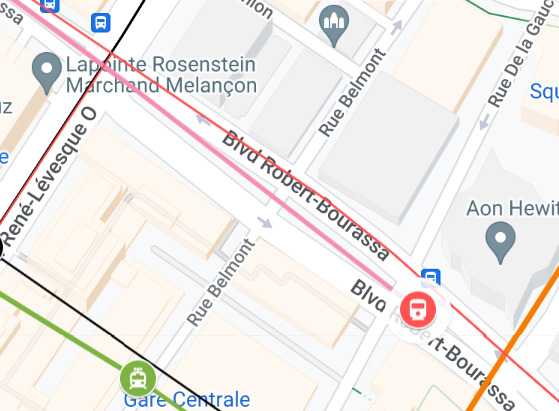
Ça serait possible de sortir un peu après René-Lévesque pour faire une station terminus sur Robert-Bourassa en aérien ou à niveau pour éviter de plonger trop profond et ainsi éviter mon tunnel ferroviaire sur René-Lévesque en gros un peu comment c’était prévu avec le REM de l’Est avec Robert-Bourassa quoi que inverser
J’avais aussi pensé faire un tunnel à une voie à partir de McGill pour éviter de devoir faire une voie de retournement et pouvoir rester dans l’emprise de Robert-Bourassa quand elle devient plus mince tandis que la ligne jaune je la terminerai un peu avant McGill avec un terminus à une voie vu l’espace limité avec un tunnel parallèle à la ligne rose qui deviendrait à deux voies pour la station McGill
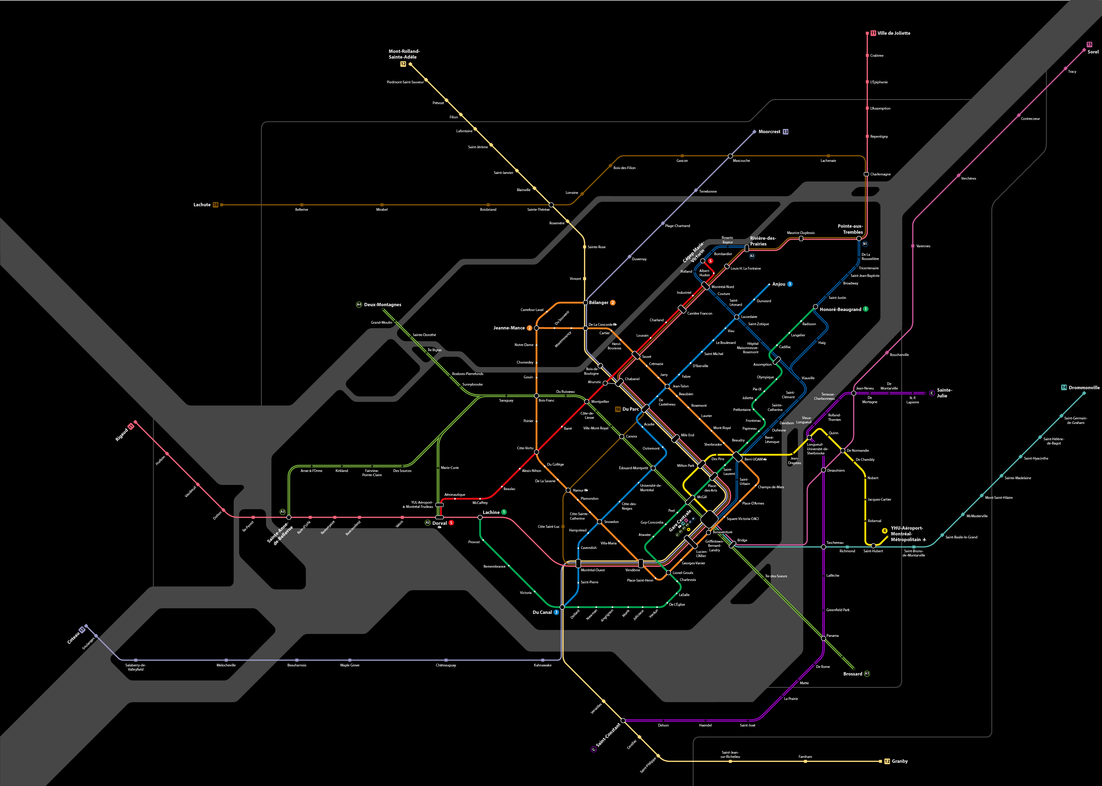
Voici mon plan imaginaire 2045 basé sur le plan de marco chitti.
J’aimerais tellement que l’ARTM ou le ministère des transports publie un vision complète pour les transports d’ici 2040. Moi je propose 3 prolongements de métro, 3 lignes exo avec des départs toutes les 15 minutes, 2 prolongement de REM, 5 lignes de tramway et beaucoup de SRB
4 « J'aime »
Question comme ça, elle est passée où la ligne de Mont-Saint-Hilaire?
1 « J'aime »
Pas assez de service pour être inclus sur mon carte. Même chose pour Vaudreuil Hudson et Mascouche. La ligne candiac (14), SJ (12) et un futur ligne Mascouche-Laval-Mtl (16) aurait un service toutes les 15 minutes minimum 7/7 d’ici 2030 alors ils sont inclus sur la carte.
J’ai privilégier Candiac, SJ et le corridor CFQG parce qu’ils ne sont pas super achalander par les trains de marchandise et il n’y a pas d’alternative attrayant pour ces regions. Il y a aussi beaucoup de TOD en construction le long de ces lignes.
1 « J'aime »
I’m guessing you’re not talking about straight up abolishing the lines, simply not including them in a map that focuses on high level of service, even if along with SJ, VH is the most frequent line and most likely to benefit from hxr?
4 « J'aime »
Yes I simply omitted VH but it would obviously still exist. Imo with the rem it doesn’t really make sense to spend money to improve VH before the other exo lines, since the rem really does most of VHs job for it.
I don’t know… we’re talking about low frequency branches of a medium capacity metro, if anything it does the job of the DM line and major bus routes north of the 40, but saying it does most of the VH line might be pushing it a little.
A similar argument could be made about the vision you’re putting forward for an improved exo15 between CSL and Anjou; there’s the blue line and the green line, the 40 is far more porous east of Acadie than west, and there’s quality of feeder bus lines that can be further improved. Maybe investments in exo15 provides more value, but not sure we can say investment in the VH line doesn’t really sense.
There’s also the issue of increasing demand east on a heavy rail line feeding into a medium capacity metro. Could be more viable if that metro is supported by a frequent complementary line like VH.
1 « J'aime »
I don’t agree that they’re comparable. VH and the rem are about 2km apart for most of their journey and the terminus of VH (Vaudreuil cause Hudson gets 1 train) is only about 10 km from the end of the rem. 10km of open freeway that will soon have bus lanes on the only choke point. The PSGSO is also going to duplicate a portion of the VH line.
Meanwhile, the end of the metro is about 20km from both Mascouche and repentigny. Mascouche and repentigny buses and commuters will also have to contend with the 40 and 25 traffic for the rest of their natural lives unless something miraculous happens.
It’s also kinda unfair to spend 8 billion serving the furthest western suburbs, then spend billions more duplicating that corridor while the Laurentides, Terrebonne, Mascouche, Repentigny have essentially nothing going for them.
1 « J'aime »
Nearly the same distance as the blue line and exo15, but landlocked by 2 highway far less permeable than the highway easy.
Are you proposing a BRT or tram like what the ARTM is leaning towards? If so I’m not sure we’re talking about duplication of a faster heavy rail line.
Might not be totally accurate for Repentigny. True for Mascouche. However, why would those bus measures work for the southwest but not the northeast?
I’m not arguing fairness, there’s always going to be some level of regional inequality. But I am wondering if pushing more people onto those heavy lines feeding into those more problematic segments of line 2 and likely line A, really the best option for the cost in terms of equity.
Because the pont Charlemagne, the pont a25, the échangeur Anjou and the autoroute 25 won’t be rebuilt in the next few decades unless a miracle occurs. There will be no big projects to speed up buses in the east.
Vaudreuil will, in the next decade, have smooth and clear bus lanes leading to a light metro station in just 10-15 minutes. Wealthy residents of Beaconsfield and baie d’Urfé will have quick buses to either Fairview or downtown, largely traffic free. Residents of Dorval, Kirkland, pointe Claire and Pierrefonds will have buses quickly taking them to either a rem station or downtown, potentially taking advantage of new brt lanes on Victoria and a nice busway on the a20. The west island will be with the rem by far the easiest suburb to get downtown from.
1 « J'aime »
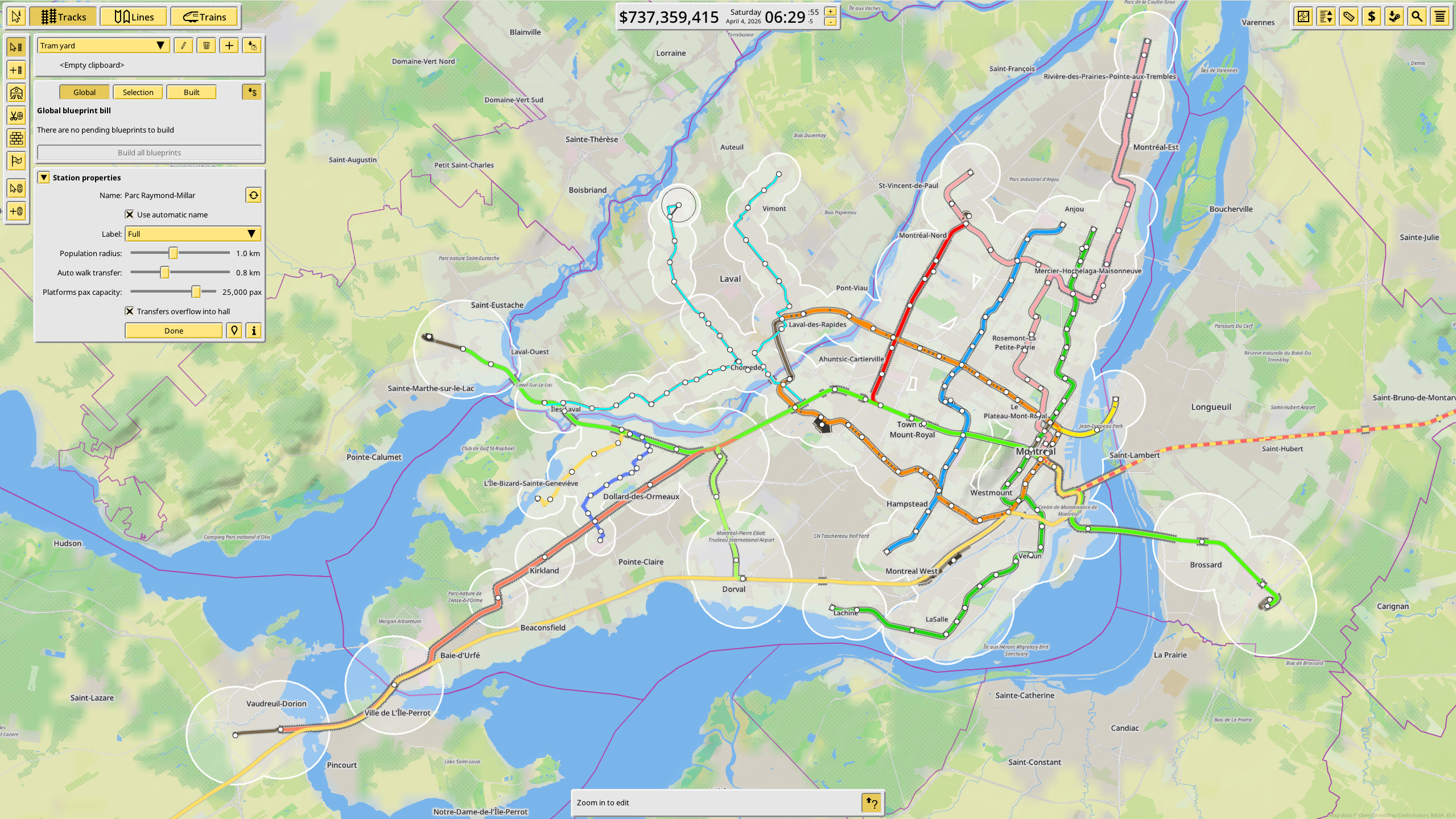
Here’s my ideal while still being realistic map of what transit should look like in Montreal (did it in NIMBY Rails, but I’m not done yet far from it. Particularly with the tram network)
I extended the A3 branch to Vaudreil (although a good bus connection would be more economical and as NIMBY rail doesn’t allow you to do buses…), the pink ish line is the REM de l’Est proposed by Vivre en Ville, it would allow to give a quick access to the people who are badly served by metro rn between the green and blue line while also connection Montréal-Nord and the East to Downtown. It’s ambitious, but realistic.
For the Orange line I made it go to the hospital in Aunthsic and I used trams to connect Laval to the metro and REM. Honestly, realistically it would be a mess to operate a loop orange line since the line is sooooo long. Also it would allow construction to be more economical since you could use cut and cover construction as your stations don’t need to be deep underground to allow the tunnel to pass under Rivière-des-prairies.
Apart of that I prolonged the green line a bit to the west, prolonged the blue line a bit west too. Oh and added the red line which would be a REM either connected to the main network or just using a transfer at station Cote-de-Liesse (which I think is preferable). Rn it doesn’t go pass the pink line, but I’m planning on expending it further East to Mascouche like the train.
Finally, I extended the A2 branch to the Dorval train station (which now has a high speed rail to it). I almost forgot, but the A3 branch passes under the Hydro lines in the west island, instead of being along the highway. I know it won’t happen since the branch is now built. But if giving people a good transportation option instead of maximizing profit, it would absolutely have been built there.
I know it’s not particularly extravagant, but I wanted to do something that could be built if we had political will to do so.
Let me all know what you think of it!^^
8 « J'aime »
There are mods for that. It would still behave like the other lines, but it gets the job done. Personally, I don’t bother with bus lines. The default station radius of NIMBY Rails is 2.3 kilometers which basically encompasses most of the catchment area that you would expect from a station that has a bus terminal attached to it. If it does not fully cover the area, you can just plop in a POI to create more demand.
I need to clean up my own map. Its way too messy to post a screenshot of it right now.
1 « J'aime »
You can do metro with nimby rail?
Yeah
A metro is basically just a tram/train generally underground that run frequently.
So you just have to find a suitable train for it (they have metro and there exist a bunch of mods for it, I personally use one that recreates 1:1 the azur metro) and run it underground (which you can)
At the core, NIMBY Rails really does not care what it is. The core elements, station platforms, line and vehicles are extremely generic. As long as it can be modded in, you can simulate it.
Nimby rails does have some limitations. It is relatively easy to autorun a line, but once you get into a 3 headed hydra like the REM, you run into problems with the scheduler. It is doable, but it is way more work than I’m willing to get involved with, so I just autorun it with numbers that get “close enough”. Weird and Wry knows that the scheduler is a bit of a chore and is currently updating it, but I get the feeling that he isn’t quite going in the right direction. He is too caught up in the want to keep everything compatible with previous versions instead of trying to make future versions as good as they can be.
The other big thing that NIMBY Rail does not do is dynamic routing. Everything follows a set route once you create a line. The train won’t switch tracks if you have a track that has a red signal and another one that is available. The only exception to this is alternate platforms.

7 « J'aime »
J’ai fait un plan de ce que j’avais précédemment proposé bon il me manque la légende et les zones tarifaires, mais sinon c’est pas mal fini!
Vous en pensez quoi?
Pour vous donner le contexte ça serait ma vision pour ce que devrais être le réseau de tc en 2060 avec les trains pensés comme RER pour certaines lignes et plus s banh pour les moins importante.
15 « J'aime »
I have to ask, we bulldozed the bell Center and make it finally a proper connexion at gc?
Also why valois instead of Pointe-Claire for the station?
I understand removing cedar park and pine beach (even tho removing them would have implications with the pre-built underpasses (something something exo is contractually obligated to maintain them indefinitely as per the joint taskforce)) but the Valois station is less valued than Pointe-Claire main station
Also with the distance, a zone E might be required(far out of territory)
I like the ideas on that map, but there’s a few things that probably aren’t possible… At a bare minimum, your red line would need to be a tramway or an underground metro. There’s no way that it can fit on that rail alignment along with the freight line and another pair of rails for your RER. If its underground, or a tramway, there’s no need to stay near the existing alignment. You could use a better alignment to serve the population of that neighborhood.
As for your plans for Gare Centrale, I think that at most, it might be possible to build a pair of stacked platforms and that’s going to require some major engineering. I’ve also extensively discussed in previous posts the reasons why it is rather hard to rise back to ground level along the Westmount sub between Vendôme and Lucien-L’Allier, so I’m not going to rehash it here. Even though it involves going through the basements and foundations of several towers downtown, I feel that it would be easier to dig a new tunnel to the back of the existing platforms at Gare Centrale.