Dans la légende, c’est marqué que c’est pour le REM !
2 « J'aime »
L’électrification de la flotte de bus sera plus rapide ainsi, plutôt que de laisser le fournisseur privé acquérir les bus.
Aussi, maintenant que les fournisseurs privés auront seulement à fournir la main d’oeuvre et non plus le matériel roulant et les garages, je pense que ça permet d’avoir une meilleure concurrence, en permettant aux plus petits joueurs qui n’auraient pas nécessairement eu une assez grosse flotte de bus, de soumissionner pour les services d’exploitation ou entretien. Genre, plus besoin d’être un énorme Transdev qui est le seul à avoir les reins assez solides pour soumissionner sur le plus gros contrat de service dans les basses Laurentides.
4 « J'aime »
Good news!! They’re correcting all the maps to show the REM stops and the correct shape of the line! Thanks @Kolev3000, I used your photo (before I saw the map myself).
10 « J'aime »
Pleasure !!
Great Teamwork that’s what Is All About…
Other, Same, Map, Jean-Talon Entrance right beside Saint-Hubert…
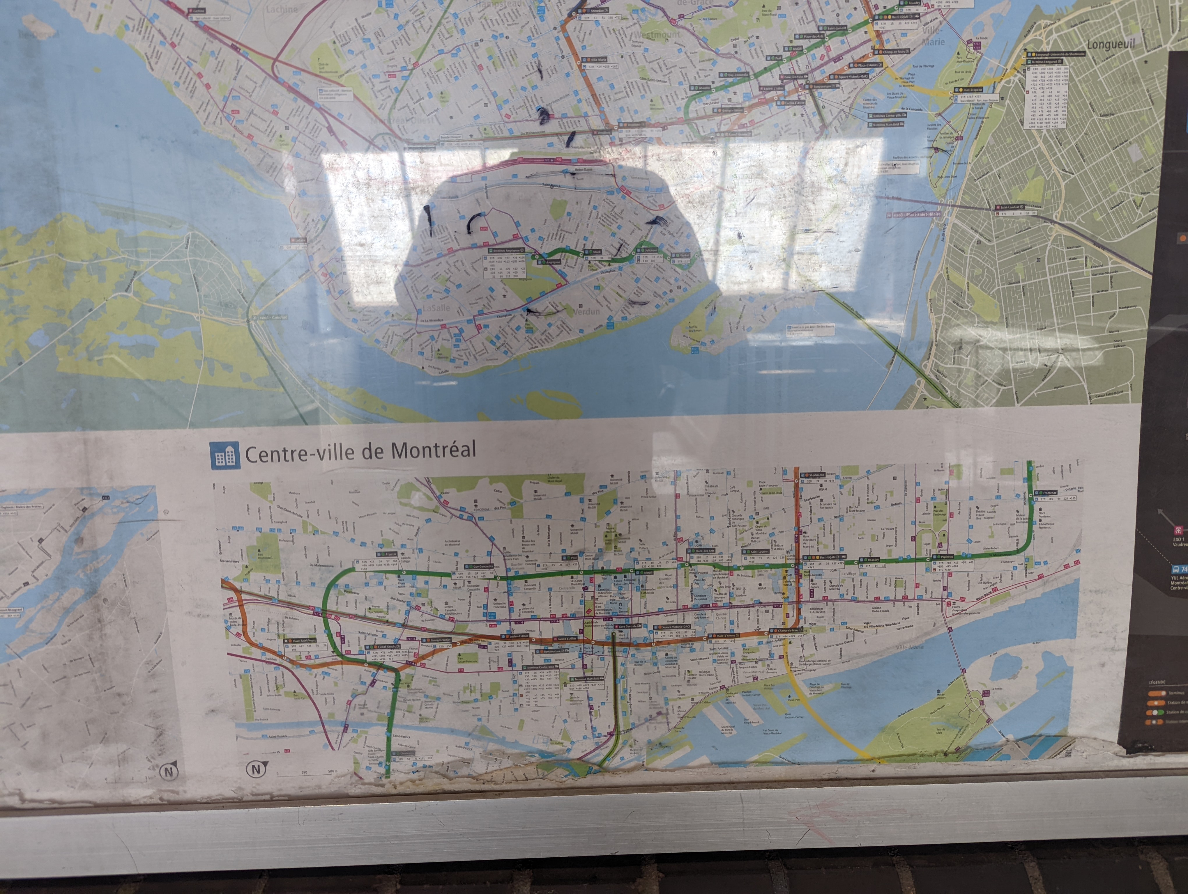
1 « J'aime »
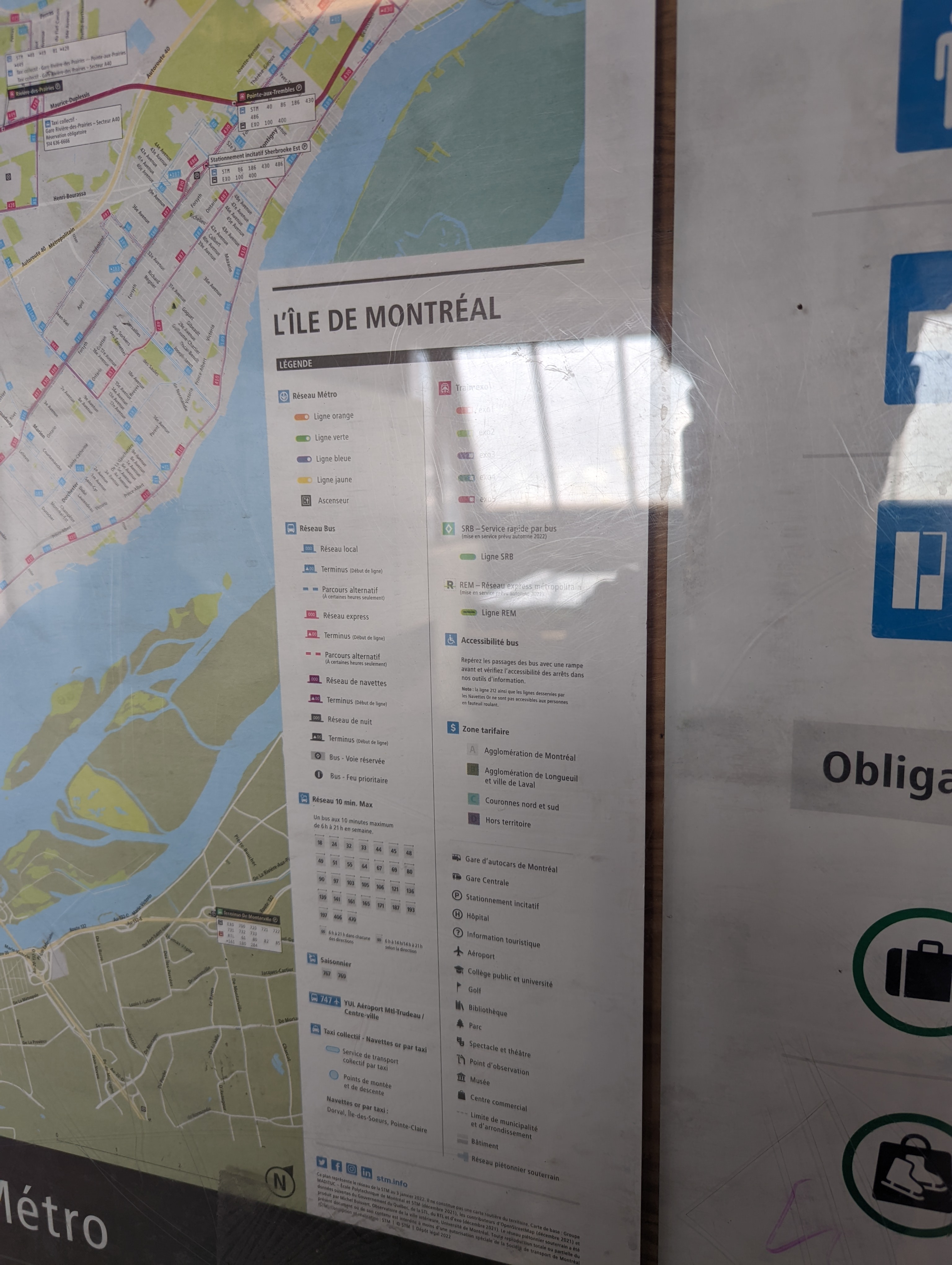
Les cartes sont changées à chaque année, des fois plus d’une fois par année.
Il était probablement prévu que les stations soient ajoutées quand les stations seront ouvertes.
2 « J'aime »
Mais alors pourquoi ajouteraient-ils la REM sur la carte, et pourquoi sous Bassin Peel, où les plans ont été modifiés depuis février 2018 et où cela n’irait pas là-bas ? Il semble qu’ils aient simplement posé la ligne peut-être en prévision de son ouverture à l’origine en été et qu’ils n’aient pas ajouté les stations lorsqu’ils l’ont retardée, mais qu’ils aient ensuite oublié de supprimer la ligne.
2 « J'aime »
Just curious, I guess it’s the best place to ask:
Does anyone know what Terminus Centre-ville (currently used by RTL and exo buses) will be used for when the REM opens?
I was hoping to move the Gare d’Autocars there and with HFR have a proper intercity hub, but thats just me and I have no info on it.
4 « J'aime »
Or maybe some buses like Trailways & Greyhound could start at Gare d’Autocars, and make a stop at Centre-ville either going to Montreal or back, so people can have two choices for being dropped off or picked up. I guess we’ll just have to wait and see in the fall!
Il y aura encore quelques lignes (celles de Châteauguay notamment)
4 « J'aime »
It should also be mentioned that the REM use the A for the line. It should then be written : Ligne A et non Ligne REM
3 « J'aime »
Oops I fixed it, I translated some of it and I guess Apple Translate chose that haha
There’s been discussion about revamping the Notre-Dame tram now that the REM de l’est is off the CDPQi books. While that can provide some additional local stops to Hochelaga, I again doubt it would satisfy the neighbourhood’s needs, given that it misses the neighbourhood to the south in the same way the Métro does to the north.
What may be the best option, at least for East-West connectivity, is to shift the Saint-Catérine route over to a restriped rue Adam, which can then run at higher frequency, covering the entire neighbourhood that is out of range of the Métro. Bare-bones service, as today, would continue along Ontario for access to shops.
The other key change would be to make the 29 a high-frequency route, preferably connected to Mont-Royal instead of Rachel. With this frequent access to the west, north-west, and along Pie-IX to the north, the neighbourhood would no longer be stranded out on a public transit peninsula.
No line or mode can address every single needs. Running a local tram service doesn’t seem to be what’s envisioned. Notre-Dame was particularly interesting for its affordable and sensible ROW for a crosstown metro link like CDPQ’s line. A metro like the REM, or a tram running all the way to Lachine like some have suggested, would address needs for long distance, higher speed service.
2 « J'aime »
Alternatively, a BRT along Notre-Dame could be interesting, as any bus line in Hochelaga could use it to reach downtown quickly.
It would also allow to extend the SRB Pie-IX towards downtown.
1 « J'aime »
And with BRT Concorde at Laval that goes right thru Laval Downtown and link to the BRT Pie-iX…
I really like the idea of pursuing a higher speed service across the island, but it needs to also be significantly faster than the Green line if we’re imagining the two corridors not being in conflict, as the ARTM pointed out for the REM B.
But what does that mean? Take Pointe-aux-Trembles as an example:
If you were to take transit from Pointe-aux-Trembles train station to Gare Centrale, it takes an hour. Along the green line, that hour is split almost equally, taking 30 minutes to get to Honoré-Beaugrand and 30 minutes on the metro. REM de l’Est was supposed to reach the trunk line in about 15 minutes, and a ride from Assomption to Berri is about 21 minutes.
If the new eastern line is similar to the REM de l’Est, that means that one could get from Pointe-aux-Trembles train station to Gare Centrale in 40 minutes. That’s a 33% saving compared to the current situation.
Do we need something even quicker than that?
Yes. For billions of dollars spent serving an axis parallel to existing service in the direction that is already well served, I’d expect a factor of two improvement in speed. A factor that permits even better cross-regional connectivity, rather than just focusing on downtown.
I’ll also note that that 20 minute improvement is only for locations next to proposed stations. Those far from the proposed stations need to walk or take a bus. The existing system already includes that access overhead, so any new system should either strive to more than just marginally improve on travel times, or provide frequent stop spacing at a similar travel time (not really possible).
1 « J'aime »