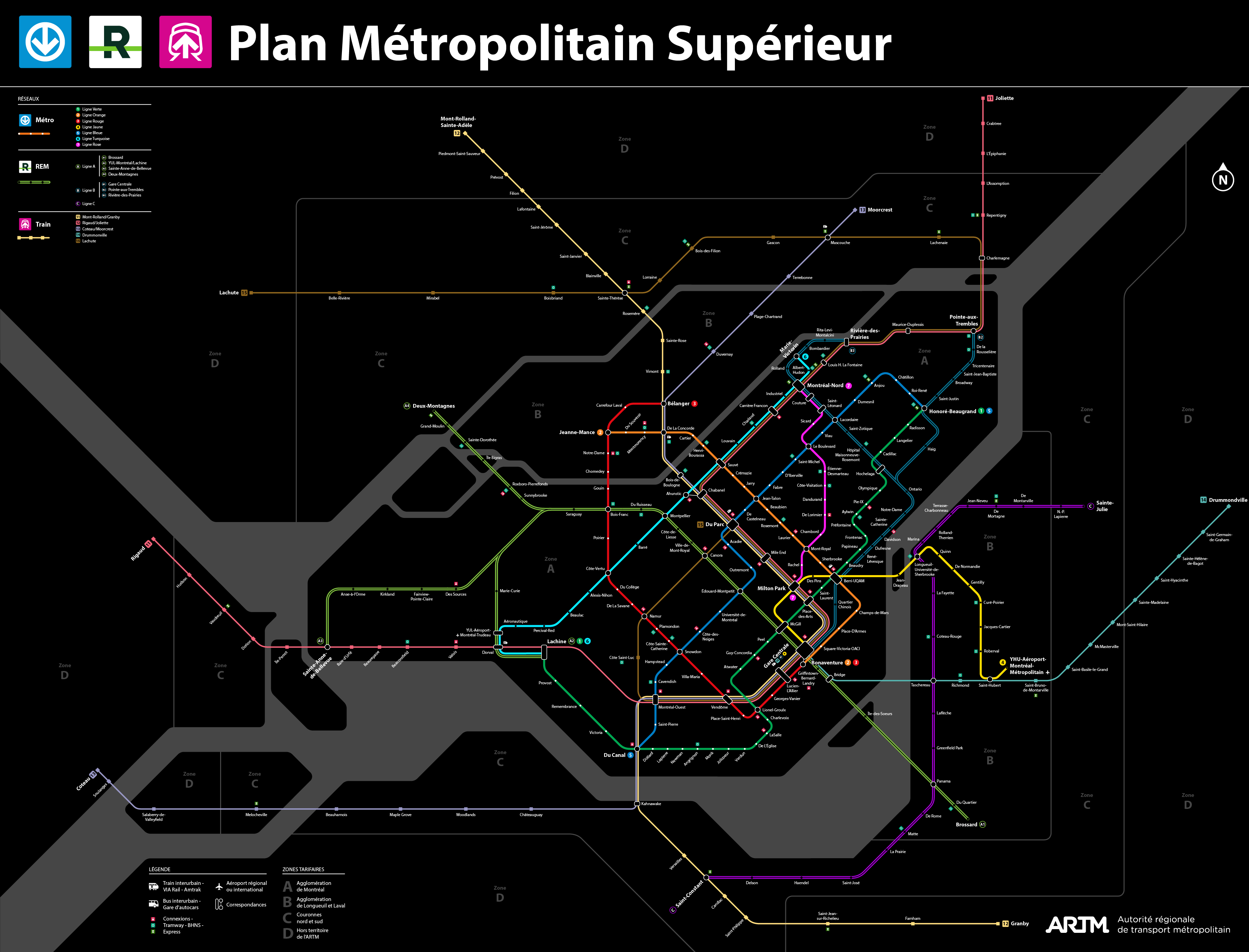
J’ai pris en partie inspiration sur sa carte pour faire la mienne puisqu’il y a certaines bonnes idées, mais l’auteur fait l’erreur de trop s’éparpiller et ne pas établir une claire hiérarchie entre les modes.
Le truc que j’ai pas compris par contre c’est pourquoi il fait autant de branches avec le REM aussi loin alors que ça serait bien mieux en termes de capacité de juste créer de nouvelles lignes. Ces métros c’est aussi un gros bordel surtout avec la ligne jaune qui parallèle la ligne bleue pour donner des exemples.
Il y a aussi des éléments avec la connectivité de son réseau qui marche pas genre de pas rassembler toutes les lignes du Sud-Ouest à Du Canal, le fait de ne pas connecter la ligne de joliette au reste du réseau en utilisant l’emprise pour un REM ce qui est vraiment sur-capacitaire et ne pas boucler la ligne orange pour donner des exemples.
La carte que j’ai fait c’était principalement pour corriger ce que je considérai comme des erreurs de conception. Surtout que le bonhomme semble très ambitieux dans son plan et ne proposait même pas un tunnel centre-ville donc je devais corriger ça hahaha.
Il semble venir de Toronto, et comme j’ai indiqué, les plans de Toronto sont très ambitieux. Sa vision pour Montréal est probablement influencé par ça. Je dois dire que personnellement, je pense qu’il faudrait imiter Toronto et mettre plus de focus sur la construction d’un réseau de RER moderne. C’est ce qui augmenterait la capacité le plus rapidement à un coût raisonnable. Les plans de métro et de tramway sont beaucoup trop centré sur le cœur de la métropole et laisse les banlieues complètement déconnecté. Les effets à Toronto sur les développements sont déjà visible. Il y a plusieurs noyaux dense en construction.
À noter que juste à faire cet exercise là das NIMBY Rail, plusieurs de mes conceptions de la forme d’un réseau de transport en commun ont évolué. Je vais définitivement revoir ma carte de Montréal plus tard.
Je suis entièrement d’accord qvec toi! Ma seule critique était que certaines lignes ne faisaient pas sens en termes de capacité et qu’il serait préférable de créer des nouvelles lignes au lieu de rajouter des branches pour des questions de fréquence gen REM Rive-Sud et de l’Est indépendant du REM de l’ouest par exemple. Sur le principe d’étendre le REM par contre je suis totalement pour!
Oui justement! Je trouve que son réseau REM se fait parfois au détriment du train comme avec la ligne de joliette et l’absence d’un tunnel centre-ville qui serait pas le plus ambitieux dans sa proposition. Mais bon après c’est pas grave considérant qu’il ne vient pas de Montréal c’est normal de faire des erreurs quand tu connais pas totalement le territoire.
J’ai retravaillé mon plan pour mettre les derniers changements dans mon masterplan, donc hésitez pas à donnez votre avis je suis curieux de l’entendre.
Il y a déjà deux axes métros dans les environs de Parc donc si dans le long termes on faisait on nouveau tunnel sous cette rue, le mieux serait clairement de rentabiliser au maximum le tunnel avec plusieurs lignes de trains de banlieues qui ont des fréquences augmentées de façon significative.
J’ai pas mal fini mon projet sur ce qu’on pourrait idéalement faire pour 2060 dans la région métropolitaine et j’ai fait deux cartes qui se parlent entre eux. Mon projet à pas mal été en réaction au PUM 2050 qui avait selon moi plusieurs problèmes, dont une trop grande concentration sur des modes léger, une interconnectivité limité et juste une mauvaise planification générale des différents modes. Je vous montre ça et en espérant que vous soyez satisfait de ce que j’ai fait.
There’s a lot of things that I like on this map, but there’s places where I wonder if that plan is technically possible. The mess of lines that you’ve got going through Gare Centrale is what concerns me most. There’s no way that you are getting both a metro line and a train station in the space bellow René-Lévesque. That implies that the only viable option for your metro station is the original CDPQ viaduct plan.
I’m also concerned about the idea of splitting the orange line. It was mentioned more than a decade ago, but I have not heard anything about that since. I just don’t know how that would work given just how densely built up that area already is. I honestly think that we might as well just leave that one alone unless there is another branch somewhere that could be built to better serve the population.
Très interessant et super beau. Mais est-ce que je peux proposer qu’on ne met pas le logo officiel ARTM sur ces plans proposés? Des fois ils se mettent à circuler et ça passe pour du officiel.
Ironiquement, c’est exactement comme ça qu’est née la carte diagrammatique qui est maintenant la manière standard de cartographier un réseau de métro. La carte non-officielle du métro de Londres était plus pratique et plus facile à lire que la carte officielle. Le fait qu’on a un phénomène similaire indique clairement que l’ARTM a encore de la job a faire.
So the REM B I imagine making a small cut and cover tunnel on René-Lévesque and put the station East of the corner of Robert-Bourassa. Since the train would be automated, you don’t need a back station so you have enough room to put the yellow line on the right of way of Robert-Bourassa that I imagined in single track since McGill and would be built with a TBM. The train line would be under the current tracks of Gare Centrale built with a deep TBM with a station at the level of Mansfield allowing to not have two station on one another.
Yeah I know, although to mitigate the inconvenients of splitting the line, I imagined automating the line so removing the need of a back station and transforming Bonaventure in an island station. So train could go into station and directly go back allowing also a cross platform transfer with the two line avoiding the current stairs.
For the splitting, I don’t know if it is still a necessity, but without information that suggest the contrary I took for granted that it would have been necessary, at worst, imagine that it still one line because we don’t really know at this point if they would feel the need to split.
I don’t think you realise just how deep such a tunnnel would need to be. There’s a rather steep terrain drop between Saint-Antoine and René-Lévesque. By the time you get to René-Lévesque, the train tracks are already at least 15 meters bellow ground. There’s another old mostly abandoned level bellow that which was once used to move various farm animals.
As far as I’m aware, the general rule for tunnels is that they need at least as much cover as their diameter. So, if you’ve got a 10 meter tunnel, that means that it needs another 10 meters of ground above it. The station itself needs corridors to connect to it. That theatrically puts that station at about 40~45 meters underground. Access would be extremely difficult, and that’s just not practical considering how many peoples would use such a station.
When I put a station there on my map, its always a station that is directly under the existing terminal, and which is dug the same way that the new concourse was dug in Toronto. I beleive that it is the most reasonable solution. In other words, I’m talking about digging an access shaft nearby, propping up the pillars and then digging under the station. We’re talking about a project that would take at least 5 years to complete, but then again, nothing is going to be quick and easy near Gare Centrale.
With this depth, indeed, it would just be better to put the new station at the level of René-Lévesque perpendicular to the current platforms. Personnally, I think that with the TGV, the current central station would be saturated pretty soon so using it to start a new tunnel would have created a major chockpoint and since the third phase it’s for 2060 I gave me some slack. However, with the number of lines that I put on my plan, I’m not sure that the ridership would be actually that low especially if you take the entire complex into account. You sure for the diameter rule because the REM tunnel is pretty close to the green line one so maybe it’s not always the case when it come to station? We can also use the old abandonned level to do the beginning of a station box like the REM could have used at the airport. The tunnel then can be do with a TBM that I would personnally start to insert into the ground at Atwater, it would be already deep thought because I would start to do cut and cover before at the highway 15. So the terrain is not really a problem since I’m the other side of the highway and you have a good 1,6 km before the central station.
I would love a 3D model of everything going on around/under the PVM/QE Hotel/Gare centrale/LIVESTOCK TUNNEL/Place Bonaventure/Station Bonaventure/Autoroute Ville-Marie complex. It boggles the mind.
Vraiment malade cette carte! Il y a beaucoup de trucs que j’aime bien et j’apprécie le réseau que tu as prévu pour la Rive-sud, c’est exactement ce que ça prend.
I’ve only heard it mentioned a few times. The only photo that I ever remember seeing is of a narrow wooden raceway used to direct animals. We likely aren’t talking about an entire level, but just a few small, rather narrow low ceiling corridors. Its likely that only one or two platforms were ever used for this purpose. I also remember that it was mentioned that theses remains had historical protection. There doesn’t seem to be much of any mention anywhere on the web, so I’m also at a bit of a loss for details here.
Edit: Here it is. I think that this is the photo that I saw.


