With a bus terminus on both sides of Marcel-Laurin at Bois-Franc station, I guess that’s their main plan to get the fastest route for Laval buses. You can see those Bois-Franc bus stops on the REM website link below.
I am curious about the bus renetwork too. Last week, I tried to make my own version of Ahuntsic-Cartierville bus map on this thread.
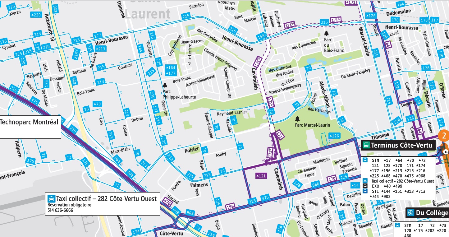
I guess one of STM first modification in mind is the end of Terminus Grenet/De Serres and welcome bus lines such as the 64, 68, 69 and 180 at Bois-Franc station.
That topic was brought up in the consultation, and the message from the public was to largely not modify the STM network in response to the REM, except around the A40 stop. The network was already designed to serve the Deux-Montagnes line. The bigger driver of changes to the network is the Bois-Franc development. Thus, the 64 should continue to serve the Metro, not to mention the many destinations between Bois-Franc and the Metro.
For the 68, it serves few addresses that can’t already reach the REM by other means, so there’s not much reason to extend it.
For the 69, yes, although it doesn’t make much sense to send such a frequent route down Gouin rather than de Sallaberry if it has to schlep back south anyways.
For the 180, yes, it should serve Bois-Franc, but the state of the western leg will depend on how service to the industrial areas is restructured.
I agree. The only thing is that this terminus is located south of the REM overpass and that Marcel Laurin rush hour traffic there is a nightmare.
There is a bus reserved lane on the whole length of Grenet, except underneath the REM overpass. Not sure if it’d be possible to add this reserved lane section and make the buses do a loop Marcel Laurin, Henri Bourassa, Grenet and Salaberry clockwise in the morning and counter clockwise in the afternoon to be against the traffic. This could also be useful for STM buses…
It would have been nice if the buses could turn right on Keller from Marcel-Laurin. It would require to add bus stops next to the north side of Bois-Franc station, where the bicycle path is.
But yes, I guess your loop on M-L/H-B/Grenet would work well with Bois-Franc station.
I would drop the 468 and 64 and extend the 68 and 69 along Grenet route to cover the current users of the 64 and serve Bois-Franc and Cote Vertu. If the timetables of the 68 and 69 are nicely offsetted, the bus service on Grenet would be just as good as now and the riders of 68 and 69 would avoid a transfer.
The idea of dropping the 468 is that the 68 would take the same route (albeit with more stops) and that many users will take the REM at Sunnybrooke and Roxboro.
I wonder if adding the 68 is necessary. It’s a very long line, it goes to Anse-À-L’Orme next to A20. I would see the 69 on Marcel-Laurin going to Bois-Franc/Côte-Vertu. The 69 Gouin could make its last stop at Henri-Bourassa station (orange line) and then create a new bus line following the REV Henri-Bourassa.
The reliability of a short route such as the current 64 is absolutely critical for the short transit journeys it serves. Any combination with the very long 68 and 69 routes would cause problems. There’s also somewhat little value in extending the 69 terminus in terms of connectivity. Those who would take it often have other routes, such as the 117, to from further east, the 171, to get to Côte-Vertu or the REM.
To put it a bit vulgarly, the 64 ain’t broke. It’s about the only high-frequency high-ridership short North-south route on the island. Don’t try to fix it.
When REM’s Bois-Franc station will open, don’t you think line 64 Grenet will lose some ridership? I mean after all, we can agree most passengers will use the REM to go north or south of rue Grenet. Some will walk too.
It will be also easier for passengers to go to “Rue Poirier” or “Galeries St-Laurent” from Bois-Franc station than Côte-Vertu station.
So yes the 64 Grenet needs to be ajusted. Probably by having the same bus frequency on both directions.
The ridership will go down a bit, but not much. Ideally, the REM station would have had good access to Rue Poirier, either by road or walk, but somehow the planning process figured drop-off curb access was more important. Given that the REM station is within walking distance of much of the 64’s catchment, it’s not actually that important for it to connect directly with the station. Keeping the 64 ‘on the way’ and maintaining access to the Métro, and as importantly, bus network at Côte-Vertu matters more.
The part of the 64 route that is far from Bois-Franc, towards Gouin, should be served by a Gouin local (either the 69 or a lower frequency local bus) that connects directly to the station.
To me, it seems obvious that a route such as the 64 would stop at both stations. Maybe I’m wrong, but there’s something there that only the STM planners would decide at the end.
Yes! Very logic. Makes sense to end the 69 Gouin at Bois-Franc station.
I’m thinking now about what the “Thimens” sector, west of Ville Saint-Laurent, is going to be. This won’t be an easy one for the STM planners. Look at the actual STM map. How could a team rethink 20-30 bus lines in a small Technoparc?
That’s a great question. How to connect this sector to both Bois-Franc and Cote Vertu without bus connections nor doubling the lines since I think there’ll be as many people living there preferring to take the REM than the orange line.
My cheating answer is to bring the orange line to Bois-Franc, which would solve the 64 line as well, but that ain’t happening…
At least the 171 should be made permanent.
No pressure STM planning team, you have my respect!
Big issue I see is that there’s two sectors actually here north and south of Highway 40. Obviously North is industrial Park Saint Laurent and South is techno Park and like we all know Highway 40 is an insurmountable wall
Keep in mind that the REM will have a greater impact on the ridership of bus lines in VSL/Cartierville/Eastern Pierrefonds than most think.
Most hubs in the area that the bus network was designed to serve -except Cote Vertu,- (Fairview, Bois Franc) will be REM stations and traveling times between them will be drastically reduced with the REM.
The train was more expensive than the bus/metro and individuals from quite dense lower income areas mainly, along Grenet near the YMCA, Chameran, À ma Baie who were avoiding the train due to the higher fare, despite the faster ride will now transition to the REM.
The 64- Grenet/Marcel Laurin corridor will see some demand for the REM/Metro transfer between Bois Franc and Cote Vertu, and the station chosen by locals will depend more on their final destination, even more with the Edouard Montpetit station unlocking a direct access to the UdeM area and the blue line without using the orange line.
There will be a clear drop in demand between Pierrefonds/Fairview and CV, except for Vanier and CSL students and people with destinations along the western branch of the orange (MUHC).
For the rest, the impact will be quite challenging to correctly predict. The novelty of the REM and the exterior views will clearly influence some rider’s choices.
I have no doubt people living in those areas (Pierrefonds to Cartierville) will take the REM when it will open. My question is not about that.
It’s more about the rest of the A3 branch (Fairview, Kirkland…). The “OrigineDéplacement” studies is not what you would expect from a suburb on Montreal’s island.
Based on Montréal’s Enquête of 2018, I took two similar sectors in Montreal considering their distance to the metro: D-D-O and P-A-T.
As in P-A-T, the percentage of people taking the metro is close to those who take the bus (61.2% metro, 87.5% bus and 4% train).
In D-D-O it’s something else (41.1% metro, 69.7% bus and 34.2% train).
The train by choice back in 2018 was the Deux-Montagnes line. So it’s obvious that those train passengers will take the A4 branch of the REM once it will open. But the A3 branch, with a train every ten minutes during peak hours? I’m not so sure.
The “enquête” of 2018 is clear about the fact people in the West Island were choosing the bus route almost twice as much as the metro for reasons of proximity, bus stops close to where they work.
I won’t say the West Island doesn’t need a metro system around their area. The demand justifies it. It’s more the way the REM is made. There should be at least one or two more REM stations between Des Sources and Bois-Franc so that the bus lines (213, 215, 225) won’t take on the REM’s ridership.
The reason they remove Autoroute 13 station is this:
" La station « Autoroute 13 » initialement prévue est retirée, étant donné le faible achalandage estimé. " ( from rem.info )
Maybe CDPQ couldn’t encourage the city of Montreal to extend the roads. Like the Thimens/Salaberry connection needed next to A13. It could be useful for buses in the industrial park of Saint-Laurent.