There will be hundreds of overpasses and underpasses constructed for alto as is done for every modern highway and tgv project across the globe. In no way will any community be “cut in half”.
10 « J'aime »
Oh wow je n’étais pas au courant! Je viens d’apprendre sur OSM qu’il y a aussi un tunnel ferroviaire entre les deux rives.
1 « J'aime »
Revenues from VIA’s Toronto-Ottawa-Montreal route are what allows us to cover most of the other VIA routes across country (except perhaps the tourist-focused The Canadian).
So, let’s pause and ask ourselves this; where are all those high paying end-to-end passengers from Montreal and Toronto right now? They’re for the most part on the road or on planes. They are not putting any money into our network.
Understanding this, but then arguing against increasing returns on that route with a project like ALTO doesn’t make much sense. Boosting ridership and fare revenue in the parts of the country that have the largest demand volume is exactly how we make the network more robust.
And I know you agree, because you brought up upgrading VIA’s Lakeshore line. Bringing that line up to standard does as much as ALTO to improve the economics on the highest-demand route, however those upgrades don’t edge out ALTO in cost, impact, and construction speed. We would be building a sensibly less competitive line (less riders to subsidise the rest of the network), but in a environmentally and socially more constrained and costlier corridor. What is theoretically feasible isn’t necessarily deployable or desirable.
So, when advocating for just upgrading that line instead of building ALTO, acknowledging that the Toronto-Ottawa-Montreal revenues are critical to the rest of the network but not that the lakeshore solution is not a particularly workable in the existing context, we’re not advocating for a real alternative, we’re effectively advocating against the current proposal.
2 « J'aime »
Fait juste un peu plus d’un siècle qu’il est là ! Et depuis la fusion entre le CP et KC en 2022, l’entente prévoit qu’Amtrak puisse l’utiliser, d’où le projet d’un lien Toronto-Chicago.
En fait, même les trains du Corridor sont déficitaires. Le manque à gagner (la différence entre les revenus et les dépenses) de 2024 était de 170M$. Ça ne paie donc pas pour les autres trains moins fréquentés ailleurs au pays.
Au contraire, chaque voyageur dans le Corridor est subventionné à hauteur de 0,24$ par mille voyagé (C’est bizarre que ViaRail utilise les milles plutôt que les kilomètres, d’ailleurs!). Ou 51,02$ par voyageur. C’est déficitaire; juste moins que les autres lignes.
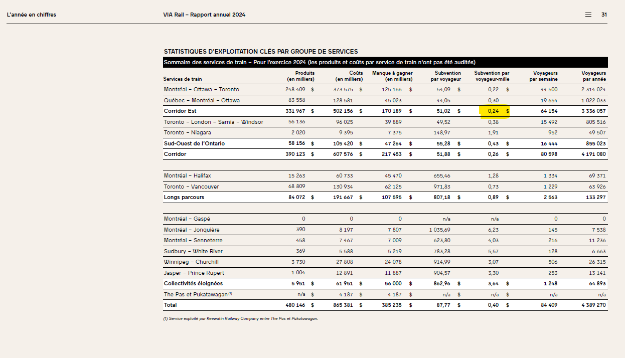
Source :rapport annuel ViaRail 2024
1 « J'aime »
tout le ferroviaire en Amérique du nord fonctionne en miles d’où les indicateurs un peu surprenant comme celui la!
3 « J'aime »
Merci pour les données. Je me suis très mal exprimer. Je laisse croire que ces lignes financent directement les autres et c’est faux. Je reformulerai ainsi; de toutes les lignes, ce sont elles qui permettent le plus à VIA d’approcher une durabilité opérationelle. Un achalandage Toronto-Ottawa-Montréal faible, c’est un réseau faible.
I don’t know how you went from HSR to the Gordie Howie bridge. Heck, that’s an international bridge to the US. You should know as well as anybody else that even the Democrats have done little for public transport. Getting such an idea over the finish line would have been a non-starter. I’m sorry to say so, but that particular post feels more like a rant than anything else. Please avoid bringing things into the subject that really have no place in it.
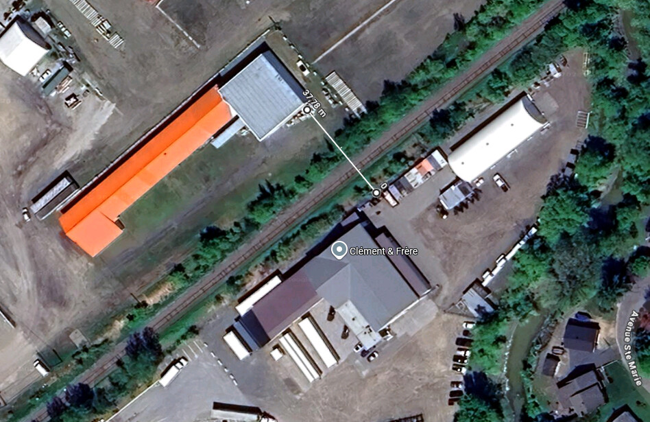
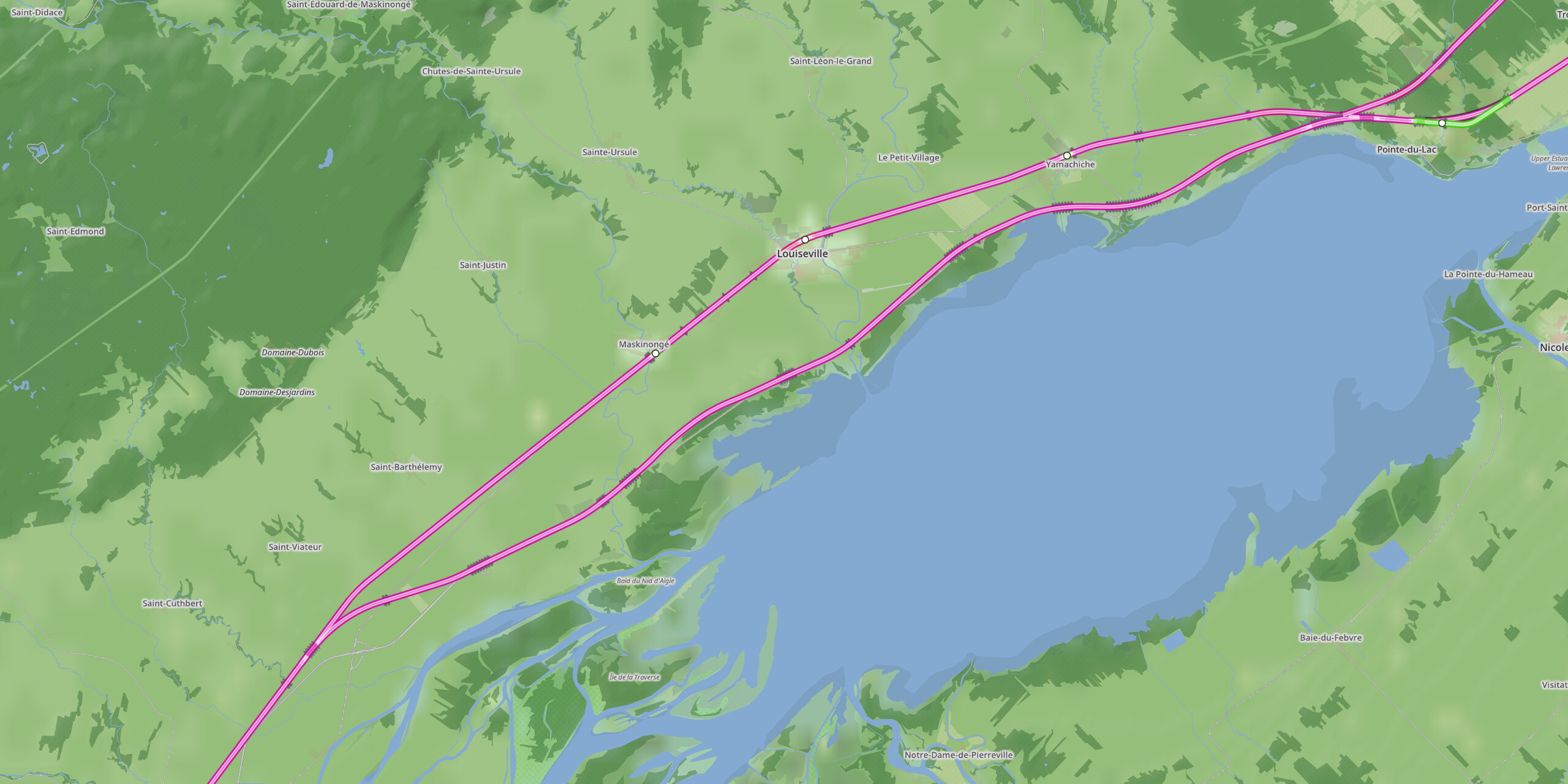
I’ve been messing with possible HSR alignments in NIMBY Rail. In Louiseville, theses 2 lines show the difference between the current max 160 km/h alignment and what it would take to create 300 km/h alignment. My guess is that this is going to be one of those unpopular opinions. Considering how little it would take to create a 300km/h alignment and that theses are mostly industrial properties, I don’t see a reason to go far afield and build a greenfield alignment.

The land for the tracks isn’t wide enough. ALTO said it needed between 40 to 60 meters. There isn’t even 40 meters between buildings in the village.
2 « J'aime »
The line clearly goes through some buildings. The implication should be easy enough to understand. I’m not fond at all of the idea of carving a completely greenfield alignment. It implies creating yet another impassible line in the land and adding more disruptions for the local fauna. I don’t see an argument for a green field alignment when you realistically only need to expropriate a few buildings to carve a right of way wide enough.
I guess that you could follow the highway along some segments, but that create its own problems given that highways typically have tighter curves than HSR allows for. There would also be a need for long bridges, or a series of tunnels at every locations where there are ramps. Reconfiguring highway ramps can add a lot of cost to the project very quickly. It is one of the thing that ended up adding a lot of cost to the beleaguered California project. We need to be rational about this and avoid increasing the cost of the project by trying to satisfy everyone along the right of way.
The problem with using the existing right-of-way is that everything around it is already developed, so any straightening or double-tracking will require expropriations, particularly around urban areas, displacing even more people. As for using highway ROW, the median is not wide enough for double tracking in most places (Including most of the 401 and 407), and you encounter the same problem as with existing right-of-way: it’s not straight enough for high-speed operation.
It may seem like spending more money for this higher speed is not worth it, but the returns on investment multiply the faster you go. Not only is there significant increases in ridership, but also frequency (faster trains=more trains) and even in labour costs (paying the same amount of wages for more services). A high speed train is, by all means, the most financially sound solution.
2 « J'aime »
What cost the less is going thru the fields. It cost way less to expropriate some lands than buildings ! Especially if you have to bulldoze houses, which will go into green field to build new ones !
It’s just impossible to satisfy everyone. What could be done to prevent taking to much land would be to build an elevated railway, but I guess that would be way too expensive !
1 « J'aime »
People would also complain about their views and such. Something is gonna have to give.
1 « J'aime »
Between Québec and Montreal, the existing railway has very long stretches where it is perfectly straight. Just between Mascouche and Berthierville, we are talking about a 60 kilometer stretch. For the Montreal-Québec corridor, the more problematic segment is between Portneuf and Québec. There’s a number of small hills. The railway isn’t anywhere near straight enough along that stretch.
You know, I wrote exactly the same thing in my previous post, and it is generally true, but I’m finding out that there are usable segments. You don’t need to go in the median. You can just build on one side of the highway.
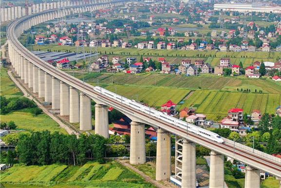
You do know why China builds on viaducts like that, right? The terrain that they have to deal with is rather unforgiving. The low lying lands near the coast and along river bassins have a tendency to flood and are waterlogged. The land to the south and west has a lot of mountains and sheer cliffs. Hence, they build viaducts to avoid having to build on a flood plain, and they build viaducts because they need to lengthen the slope to climb mountains.
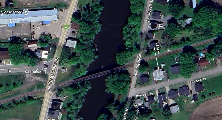
The problem in Louiseville is the crossings. rue Notre-Dame (and Royale) especially, with the river being so close, you have no choice but to have the railway on a bridge there.
100 milliards $ sur 15 ans c’est 6,6MM$ annuels, soit 1,3% du budget annuel de 487MM$ du fédéral. Sans oublier l’accroissement prévu annuel du PIB directement imputable au TGV qui n’existerait pas avec un simple TGF.
Donc je pense qu’il y a moyen d’avoir plusieurs priorités, surtout que comme d’habitude avec ce genre de projet, il y aura toujours une autre urgence et qu’il n’y aura jamais de bon moment.
Finalement la plupart des propositions mentionnées sont de la responsabilité provinciale, donc il risque de n’y avoir pas plus d’argent.
1 « J'aime »
A noter que l’accroissement du PIB annuel imputable au TGV avoisine les 24G$, donc s’il y a juste le tiers de ça qui retourne aux gouvernements provinciaux et fédéral, ça donne donc 8G$ de revenus supplémentaires pour des projets de rénovations d’hôpitaux, d’école ou peu importe ce que vous voulez payer. Et c’est à chaque année.
For an alternate Greenfield route for that section, this is what I landed on. Rather than trying to go around the city and come back to the alignment, I just followed the highway for a while.
Part of why I want to stick to the existing alignment as much as possible is that I beleive that it would be foolish to spend that much money and not plan for local service. With proper timing, the local service could be parked in station while the HSR passes through. Given the population density, I have no reason to beleive that such a service would ever be built if we were to bypass those communities completely. It would be a missed opportunity that would consecrate the car as the default mode of transportation for the next generation.
___________________________________________________
I’m working on the next segment toward Québec right now. Its going to need more work. There more curves along both the highway and the existing railways.
The alignment proposed in this study seemed promising at first, but I’ve been finding that there are several issues. The proposed right of way runs close to the foot of the Laurentides. There isn’t any huge communities, so at first, it seems like a sure bet, but when you zoom in on Google Earth, you quickly find out that there are actually quite a number of scattered homes. As it happens, peoples like to live in high places and have a view. Theses are sleepy places that I do not expect would take kindly to HSR barging in.
Another thing worthy of note about this study is what we learn when we compare it to the outline that we see on the Interactive Pin Map that you can see on the Alto website. For the segment between Laval and Trois-Rivière, the alignment proposed by the study is clearly not being considered. We know that because the outline is mostly located between the existing alignment and the highway.
___________________________________________________
Bonus: Some will note the X on the right near Trois-Rivière. Initially, I wanted to reuse the existing station, but I’m coming around to a more northern station along the unused highway 40 alignment. Part of why I’ve changed my mind on this is that the freight yard is hemmed in from all sides. Access would be rather difficult for both busses and cars. The main thing going for that location is the fact that it is near the touristic part of town.
Initially, a more northern location would not have worked with the other ideas that I have, but I’ve found ways to make it work. The bigger issues that I have with that location is how to get out of Trois-Rivière on the eastern side. The highway has a serious kink in it. There’s also a series of homes in the way as well as what looks like a marshy prairie. There’s also a waste water treatment facility nearby. That part needs more thinking.
Je crois que je suis le seul à penser que le TGV et le REM peuvent passer par le Vieux-Port pour se rendre dans l’Est et partager une partie des voies.
Quand on y pense, ça fait du sens, le Vieux-Port et le Port appartiennent au Fédéral, pas besoin de les exproprier. En plus, c’est 10 kilomètres de moins pour se rendre à Repentigny que de passer par Laval.
Est-ce que « les sceptiques seront confondus, dus, dus, dus? Oh, oh, quel beau du! » ![]()