Would it make sense if going forward when the STM installs new signage, they include the number of the line on the signs, to follow the new maps?
2 « J'aime »
Il y a pourtant en masse de villes (New York par exemple) où des stations portent le même nom car croisent les mêmes rues. Surtout sur Manhattan, avec 4 tunnels en parallèle, il y a fréquemment 4 stations avec le même nom, s’agit de savoir sur quelle ligne on doit être pour avoir la bonne station !
Si on sait qu’on s’en va proche de Pie-IX et Rosement, facile de savoir qu’il faut prendre le SRB et descendre à Rosemont. Peu probable qu’une personne pense devoir descendre à Rosemont de la ligne orange.
Autrement, pourquoi mettre une ligne sur une carte si on ne met pas le nom des arrêts ? Aussi bien retirer le SRB si on a pas la place pour indiquer ses stations !
1 « J'aime »
C’est juste une ligne de bus qui s’arrête à tous les coins de rue. Même les points sont inutiles.
A Montreal contrairement à NY on a pris soin de ne pas dupliquer les noms de stations. On aurait pu facilement se retrouver avec deux stations Papineau, Saint-Laurent, etc.
Personnellement ça m’a pris quelques années avant de comprendre que De Castelnau c’est a l’intersection de Jean-Talon/Saint-Laurent.
Maintenant il y a LaSalle et Lasalle, faudrait en profiter pour corriger cette aberration et renommer LaSalle pour Caisse.
2 « J'aime »
Tout à fait d’accord, ce n’est qu’une ligne d’autobus, pourquoi la mettre sur cette carte alors que le SRB Côte-Vertu—Sauvé n’y est pas ? Il y a des cartes en station exprès pour couvrir l’ile au complet !
1 « J'aime »
“On se fait une escapade en train au Mont St Hilaire cette fin de semaine?” Imagine la déception…
3 « J'aime »
Il faut quand même reconnaître que le SRB Pie-IX n’est pas du même niveau que les autres SRB…
2 « J'aime »
Le SRB Sauvé-Côte-Vertu n’est pas un SRB, voilà pourquoi.
Il devrait y avoir des niveaux de SRB et ceux qui sont du niveau de Pie-IX se retrouveraient sur la carte métropolitaine, les autres non.
9 « J'aime »
La STM continue toutefois de considérer l’axe Sauvé/Côte-Vertu comme un SRB. Un débat peut évidemment se faire sur l’application de cette dénomination à une ligne de bus avec des fréquences de passages aux 15 à 20 minutes hors-pointe. Mais officiellement, il n’y a pas de distinction entre Sauvé/Côte-Vertu et Pie-IX en tant qu’axes SRB.
La présence des lignes SRB sur les cartes va devenir de plus en plus complexe à gérer dans les prochaines années avec l’ajout de nombreux nouveaux axes, dont Henri-Bourassa et Parc. D’ajouter certains axes alors que d’autres seraient ignorés complexifierait la planification des déplacements pour les usagers.
1 « J'aime »
Le genre de problème dont je m’accommoderais bien ![]()
EDIT : syntaxe
Sur la plupart des cartes de transit que j’ai vu, les SRB sont omis. Notre métro est encore relativement petit en comparaison à d’autre, mais il y a déjà une densité assez importante d’information sur la carte.
Au niveau métropolitain (la portée de la carte) il y en a une et elle est assez significative ![]()
Transit Maps wrote a review of the new map…
Transit Maps: Submission – New Official Map: “Harmonised” Montréal Metropolitan Transit Services Map, 2023
July 16, 2013
A flurry of people have submitted this brand new map out of Montréal for review, so let’s get straight to it!
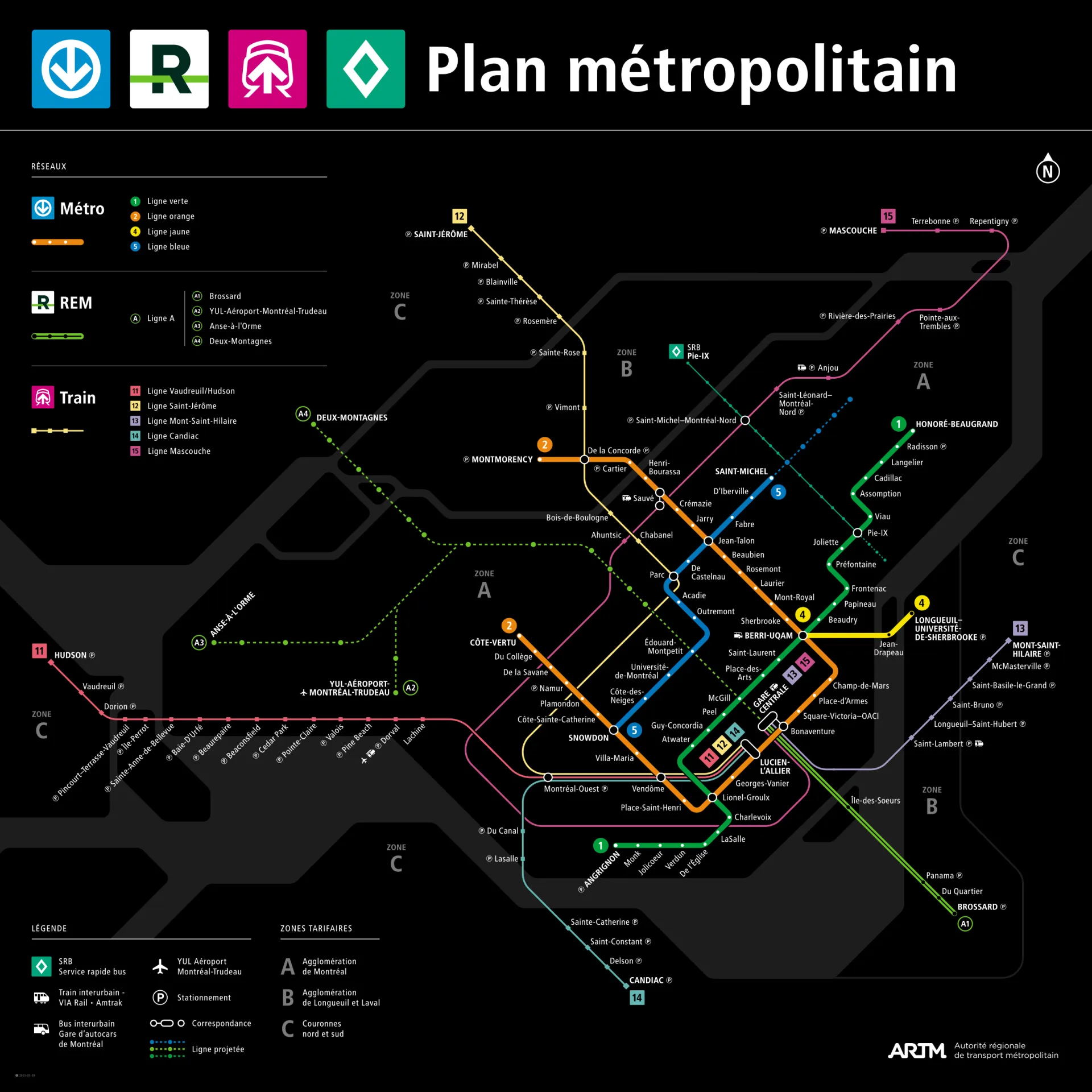
First of all, it’s important to note that is part of a new suite of maps and wayfinding signage that’s been in development since 2018. Using Montréal’s iconic “black background” Métro map as a starting point, this system has been intentionally designed to use a common design language to “harmonise” the user experience for transit users regardless of travel mode. As seen in the photo below, there’s already a new Métro map out in the wild that uses the same design language, although everything has been subtly tweaked to suit the content of that smaller scale map better – look at the comparative thickness of the Métro lines, for example, or the fact that no stations on the REM or suburban lines are named unless there’s a direct interchange with the Métro.
Note on this photo: Quite a few people sent me this image, which I’ve straightened and brightened in Photoshop. However, I don’t know the original provenance of the picture. If it’s yours, please get in touch so that I can credit you appropriately!
When I last reviewed the Montréal Métro map back in 2016, I wasn’t very impressed – it had moved away from its truly iconic 37-degree tilt to a more standard 45-degree octolinear form and just didn’t seem very polished or confident. It very much seemed like a transitional map, a placeholder for something better in the future… and I think the wait for this suite of new maps has been worth it.
Basing these new maps off the existing Métro maps provides great visual continuity with what has come before, but there’s also a lot of improvements – mixed-case station labels instead of all-caps (finally!), numbered bullets for not only the Métro lines but also the suburban rail lines, and a lovely palette of subsidiary pastel colours for the other services. Using a more standard 45-degree form makes sense now with the increased complexity of the maps, and the way that the space between lines 1 and 2 in the central part of the city has been increased to accommodate the rail stations and their labels is rather clever.
Purists might grumble about the horizontal orientation of the southwestern end of Line 1 (it just looks wrong, even to me as a non-native), but it seems like a pragmatic decision that allows Line 14 to slot in below it on the full system map, and the legend to do the same on the Métro version.
The stylised background representation of the complex geography of the area seems about right to me: it’s not overly-detailed “faux geography”, nor is it simplified to the point where nothing is recognisable. Definitely an improvement over previous maps in my eyes!
I also like that the maps are future-proofed – the branches of the REM line and the future expansion of Line 5 are already plotted in, and it looks like there’ll be adequate room for labels as well – great to see! Not sure there’ll ever be full labelling for the Pie-IX rapid bus line, but it’s a long way down the hierarchy of the map anyway!
The “two-circle” interchange symbol at Sauvé seems a bit fussy to me, especially if you consider that by rights there should be one at Parc as well – there’s an outside walk involved in the transfer at both stations! A minor inconsistency, but something that should be carefully thought about. I’d probably simplify it down to a single dot for simplicity’s sake.
Our final word: A massive improvement over the 2016 Métro map, and the fact that it’s part of what looks like a strong unified wayfinding and signage program makes it even better. It pays homage to the past, while also looking confidently ahead to the future of transit in Montréal.
Source: ARTM website (in French)
6 « J'aime »
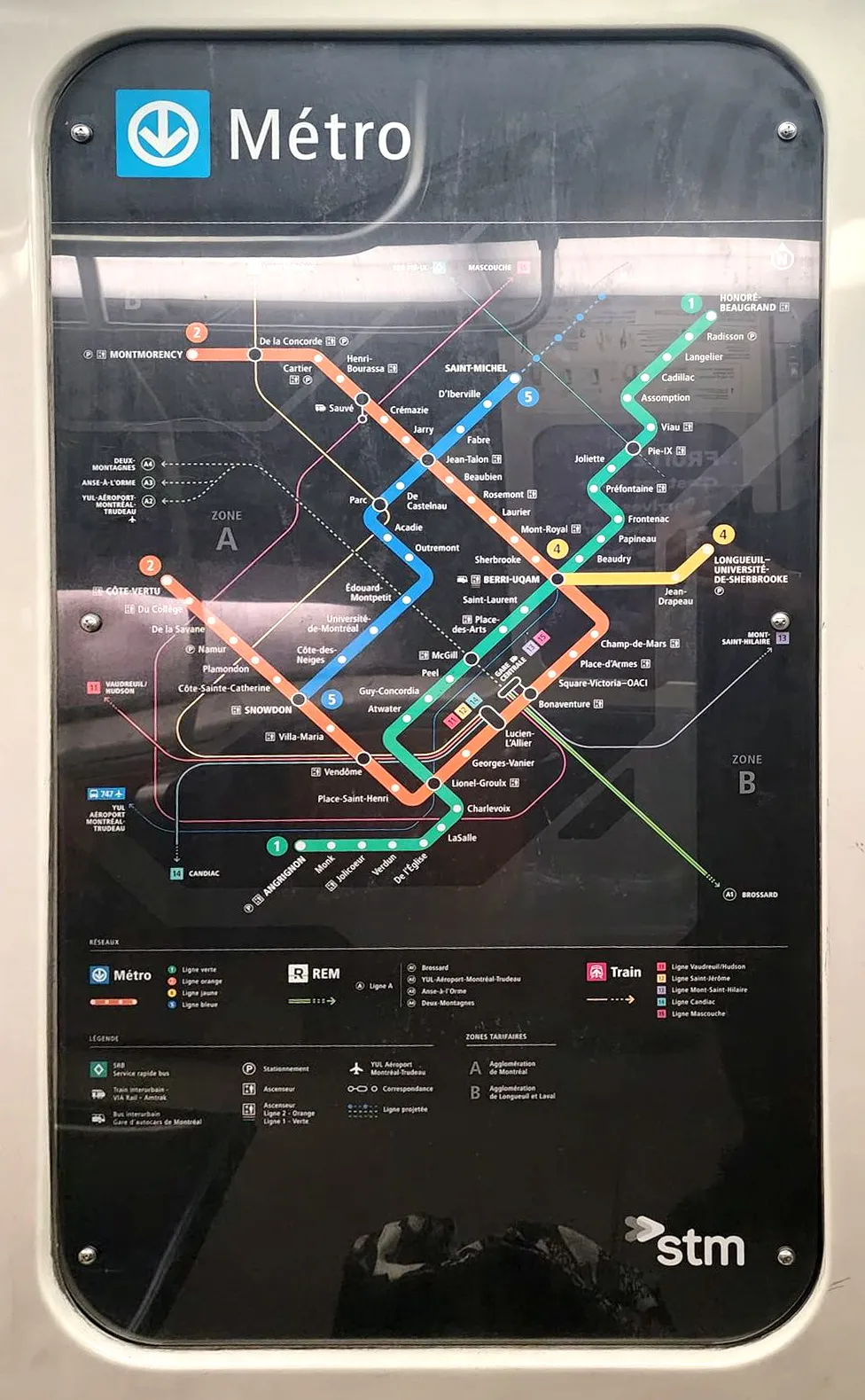
Visiblement, je n’étais donc pas le seul à lui rapporter la nouvelle carte ![]() J’aurais aimé une critique de sa part plus exhaustive sur la version vue dans les rames de la ligne bleue par contre. Elle me semble moins réussie.
J’aurais aimé une critique de sa part plus exhaustive sur la version vue dans les rames de la ligne bleue par contre. Elle me semble moins réussie.
1 « J'aime »
J’apprécie que ta carte essaye de montrer plus clairement le réseau de bus, ne pas avoir les autres rues qui occupent l’espace de la carte aide beaucoup par rapport à celle officielle.
Par contre je suis pas sûr d’avoir les lignes de la même couleur les unes par dessus les autres, comme sur la carte officielle ça reste difficile de suivre une ligne de bus d’un coup d’oeil de loin
Si t’arrives à faire ça chapeau, avoir autant de lignes faciles dans une image facile à digérer c’est pas facile
Je veux corriger la ligme 3 fantôme, c’est tellement tentant d’insérer le REM à la place, et ainsi aussi enlever le branding séparé pour un réseau à une ligne
1 « J'aime »
Hopefully it’s ok, I’ve adjusted the header slightly as this signage now covers more of the entire ARTM network, and not just the STM now. People were talking about a graphic design chat, and I think for transit related things within the ARTM network (ie. signage/wayfinding, the new maps, etc), then this would be the right place!
3 « J'aime »
New signs have been installed at Bonaventure station for the bus terminal and REM… and they look awful who thought this looked good. It says Gare Centrale multiple times (on the old sign the C is small, on the new one the C is big), on the new signs it doesn’t even say “Terminus Centre-ville,” it just says “Terminus,” and there’s literally text overlapping the new signs:

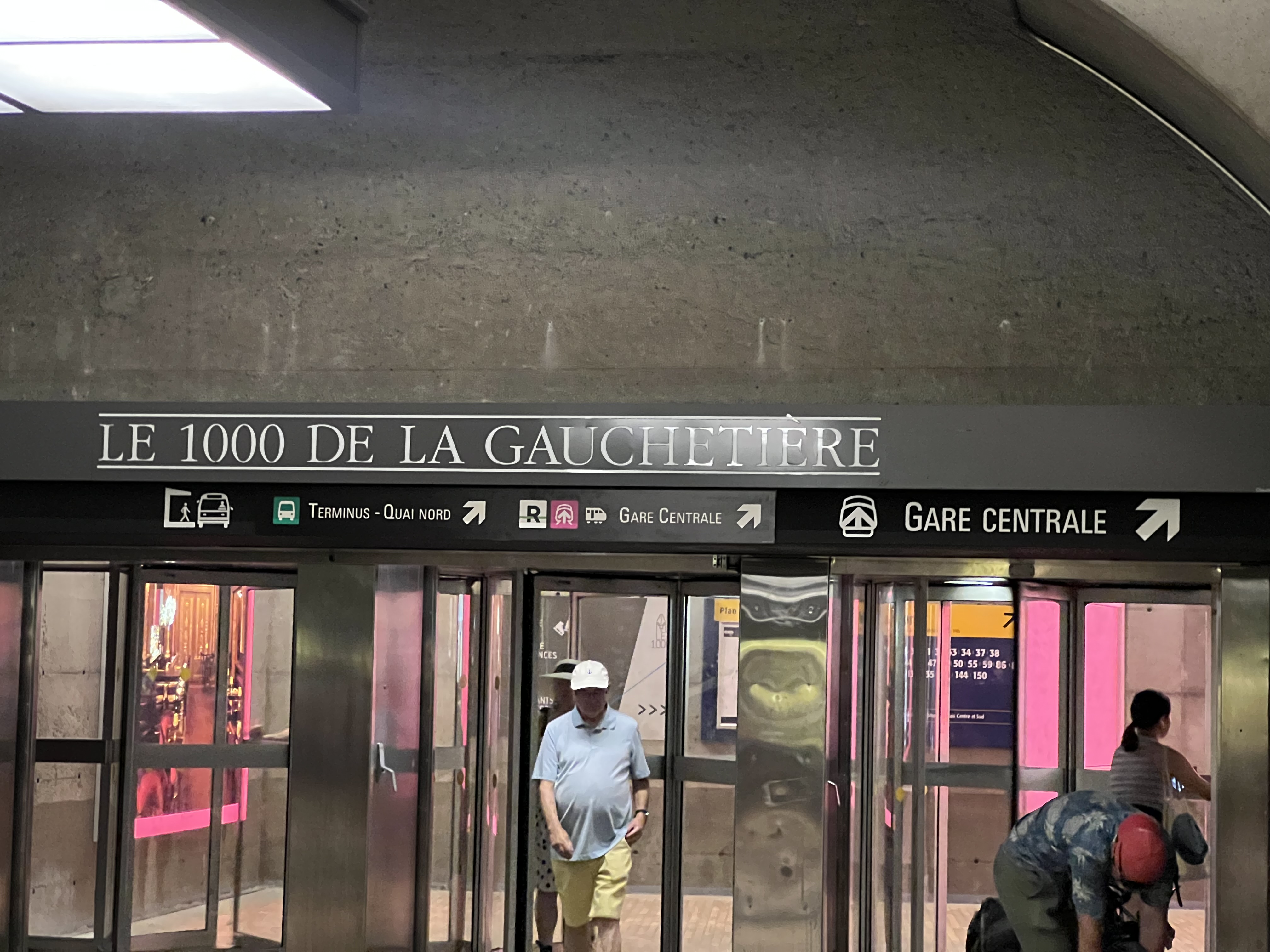
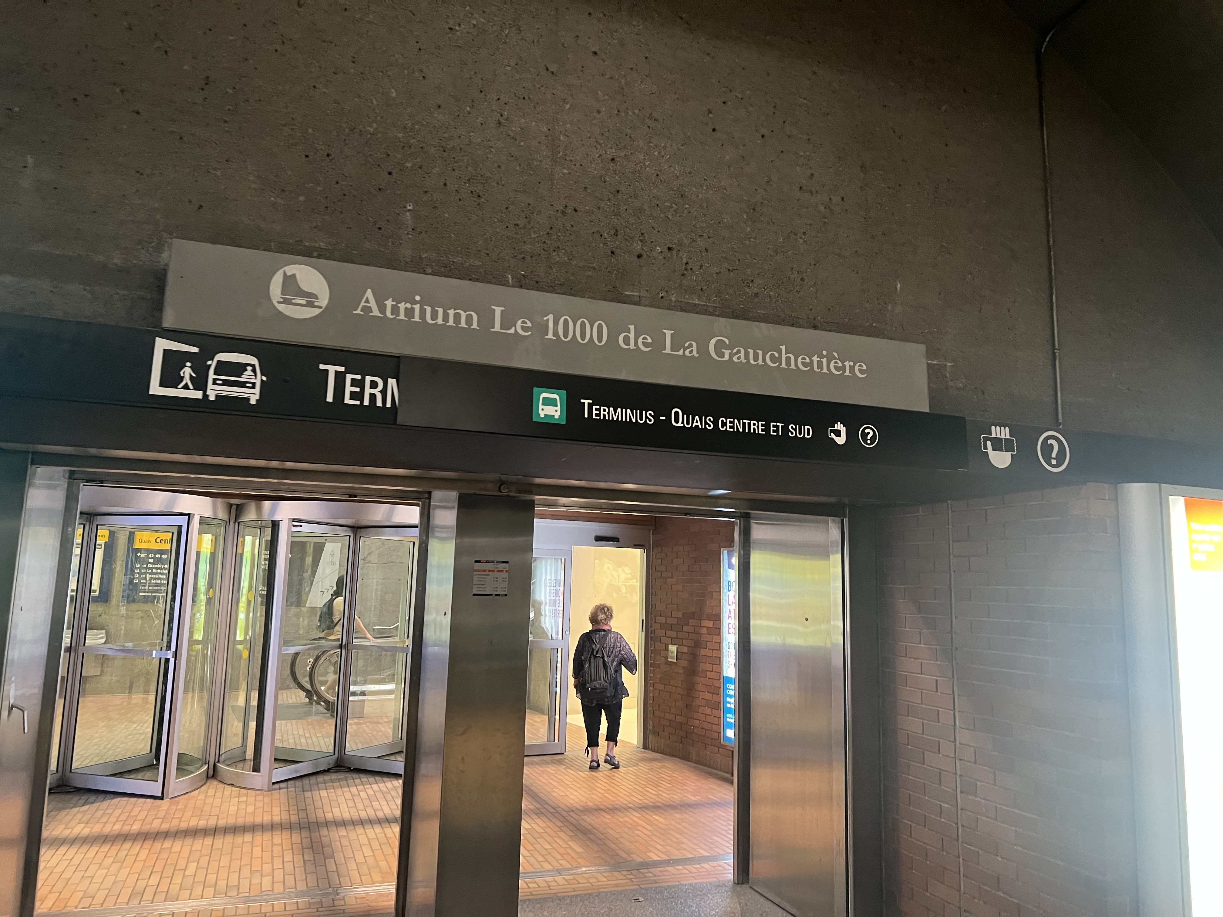
They really need to overhaul the entire signage in this station to follow the new standard, I think that’s worth it even if it includes replacing the light fixtures.
5 « J'aime »
I have been there less than about an hour ago, and I didn’t even notice them ![]()
Looking at the pictures, it makes me wonder if they will rename the terminal station to “Bonaventure”.
1 « J'aime »
I was actually thinking that too, it might make sense, because it clarifies where the bus terminal is, and would be more clear than just “Centre-ville.”
Although I just remembered, the REM has signs that say “Terminus Centre-ville” so they’d need to replace those if they do plan on changing the name
The old signage looks awful when mixed with the new logoes and icons. Why couldn’t they juste use the new typeface, small caps are not very legible and look ugly.
2 « J'aime »