J’ai remarqué tantôt que l’intersection St-Antoine / Greene (Ouest) semble être aménagée pour permettre un raccordement avec deux pistes unidirectionnelles sous l’autoroute:
5 « J'aime »
Le sujet de la piste cyclable 24e avenue a été abordé lors du dernier conseil d’arrondissement de VSP. Selon Sylvain Ouellet, le projet est bloqué à cause de l’impossibilité d’ajouter un feu de circulation à l’intersection 24e/Crémazie. Ils seraient en discussion avec Saint-Léonard pour passer par Provencher; Saint-Léonard aurait demandé une étude de faisabilité là-dessus. Bref, le projet n’est pas techniquement mort, mais ça augure mal…
1 « J'aime »
C’est à ni rien comprendre. Quand la 439 passait par là durant les travaux sur pie-ix y’avait bien un feu de circulation la…
Ma compréhension c’est que c’est le résultat d’un changement réglementaire à la loi provinciale sur les ingénieurs, entré en vigeur en 2020. Il est désormais obligatoire d’avoir l’approbation d’un ingénieur pour faire des changements de signalisation alors que ce n’était pas le cas auparavant.
Je ne connais pas suffisament le domaine pour savoir si ce changement réglementaire est positif dans son ensemble, mais anecdotiquement ce n’est pas la première fois que des changements que je juge nécessaire sont bloqués par un ingénieur qui semble accorder une priorité absolue à la fluidité automobile aux dépens de la sécurité des usagers (ex. refuser un stop à une traverse piétonne dangereuse en corridor scolaire).
2 « J'aime »
Il y a du positif et du négatif là-dedans. Le positif c’est surtout que les conseils municipaux installaient des panneaux d’arrêts n’importe où et dans n’importe quelle circonstances. Faut se rappeler qu’un panneau d’arrêt, tout comme un feu de circulation, c’est un outil de gestion des flux, pas une mesure d’apaisement.
Ex: Dans RPP sur Beaubien à l’est de Saint-Michel, l’arrondissement a mis des panneaux d’arrêts entre les lumières, donc essentiellement on arrête à chaque coin de rue. Il y a tellement d’arrêts que les automobilistes glissent systématiquement leurs stop et les piétons ne sont pas plus considérés. En même temps, le bus 18 lui fait ses stops en bonne et due forme et est donc encore plus lente que jamais. Donc pas terrible comme aménagement.
Le nœud du problème c’est pas le mode de gestion des flux dans une intersection mais l’aménagement comme telle de nos rues, qui sont pas à échelle humaine du tout.
Sinon le côté négatif du changement réglementaire c’est que maintenant changé la signalisation c’est long. Dans le cas de la 24e et Crémazie, c’est une intersection régie par la ville-centre et donc les élus de l’arrondissement n’ont aucune poigne sur le dossier, donc c’est encore plus long.
1 « J'aime »
Dans les documents décisionnels du dernier conseil municipal on retrouve une liste d’études qui seront réalisées par le Service d’urbanisme et mobilité (SUM), dont plusieurs concernent des aménagements cyclables potentiels. Évidemment on parle d’études seulement à ce stade-ci, mais je trouve ça intéressant dans la mesure que ça donne une idée de ce qui pourrait se dessiner à l’horizon.
Dans le contexte du prolongement de la ligne bleue:
Validation et optimisation de la mobilité et de la sécurité des usagers modes actifs (Langelier et Anjou);
Secteur Bridge-Bonaventure:
Faisabilité de franchissements du canal de Lachine (liens actifs);
Sous la rubrique “Programmes d’aménagement” (pas certain si c’est nécessairement du cyclable):
- Van Horne -besoins et familles de solutions (suite de l’étude);
- Études de mobilité et gestion des parties prenantes pour les projets Laurier, Hochelaga et boulevard Rosemont (programmation 2026);
- REV Jean-Talon -Analyse phasage et étude de solutions;
- REV Jean-Talon -Avant-projet Jean-Talon Phase 2.
A40 dans le coin Papineau/De Lorimier:
Analyse des concepts pour relier piste cyclable du parc Frédérick Back dans
le secteur Jarry-Bordeaux.
Projet Corridor Samuel-De Champain:
- Interventions requises pour harmoniser les liens cyclables;
- Étude de faisabilité et analyse requise pour prolonger le nouveau lien cyclable qui
sera construit sur la rue Marc-Cantin.
Véloroute(REM)
- Études de faisabilité technique et financière et élaboration des concepts d’aménagement et des études complémentaires requises en lien avec la
véloroute;- Études de faisabilité technique et financière et toutes autres études
complémentaires. (Emprise Deux-Montagnes).
“Parcours signature Montréal” (je ne connais pas mais semble concerner IDS?)
- Étude lien multifonctionnel Transports actifs - REM;
- Élaboration du concept d’aménagement de la rue du Pont Champlain et de sa
piste cyclable.
Lien TA/TC de l’ouest, REM Kirkland:
- Études complémentaires transports actifs pour connexion aux réseaux existants;
- Étude et concept du seuil d’accueil Rivière-des-Prairies et jonction Gouin (lien avec Grands parcs).
Chantier REM:
- Réaliser l’étude de concept pour construire un lien de transports actifs au parc
des Rapides-du-Cheval-Blanc;- Réaliser une étude pour le réaménagement du sentier Bois-de-Liesse en vue de
la sécurisation du lien cyclable (lien direct avec la Véloroute).
Voir pp. 1023-1027 de ce PDF (attention il pèse 300Mo). Je vous encourage à y jeter un coup d’oeil, je n’ai pas l’énergie d’aller mettre l’info dans tous les fils différents mais il y a mention de beaucoup de projets suivis par ce forum (école primaire Griffintown, MIL, Quartier Namur-Hippodrome, Bridge-Bonaventure, Assomption et j’en passe)
4 « J'aime »
OUI SVP SVP SVP SVP SVP
2 « J'aime »
Dans le journal local d’Ahuntsic-Cartierville
En plus du Corridor de mobilité sur le boulevard Henri-Bourassa déjà annoncé précédemment, un ajout important est le lien cyclable sur la rue Meilleur entre la rue Fleury et le boulevard Crémazie.
[…]
La Ville-centre a annoncé également les nouveaux liens et améliorations suivants:
Des ajouts de quais pour les autobus et de traverses piétonnes à mi-îlot sur l’avenue Christophe-Colomb;
La piste sur Gouin Est de la rue Bruchési et jusqu’à J.-J.-Gagnier sera rallongée;
Une bande cyclable sur la rue de la Paix et la rue Jean-Massé sera installée pour permettre d’accéder au passage sous la gare Du Ruisseau du futur Réseau Express Métropolitain (REM);
4 « J'aime »
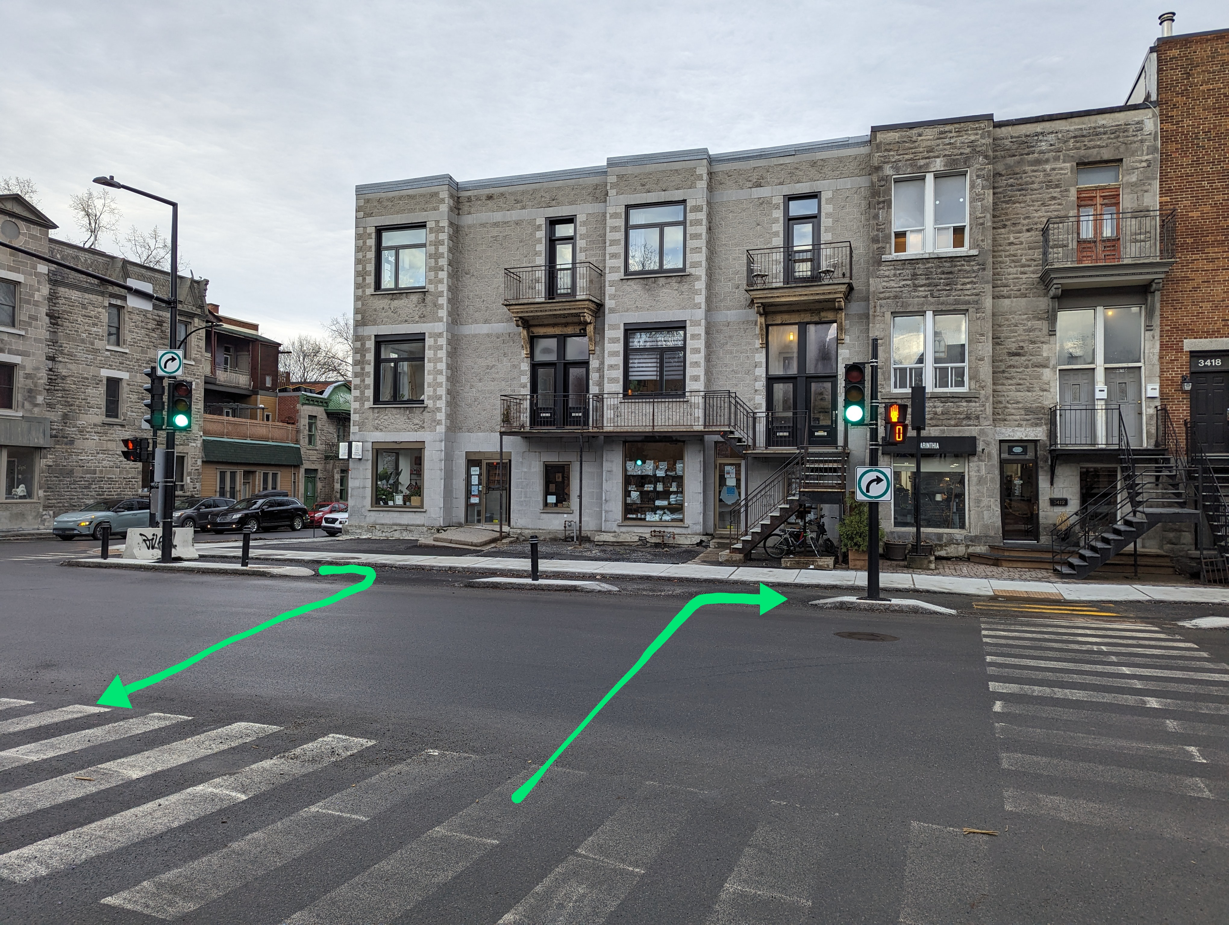
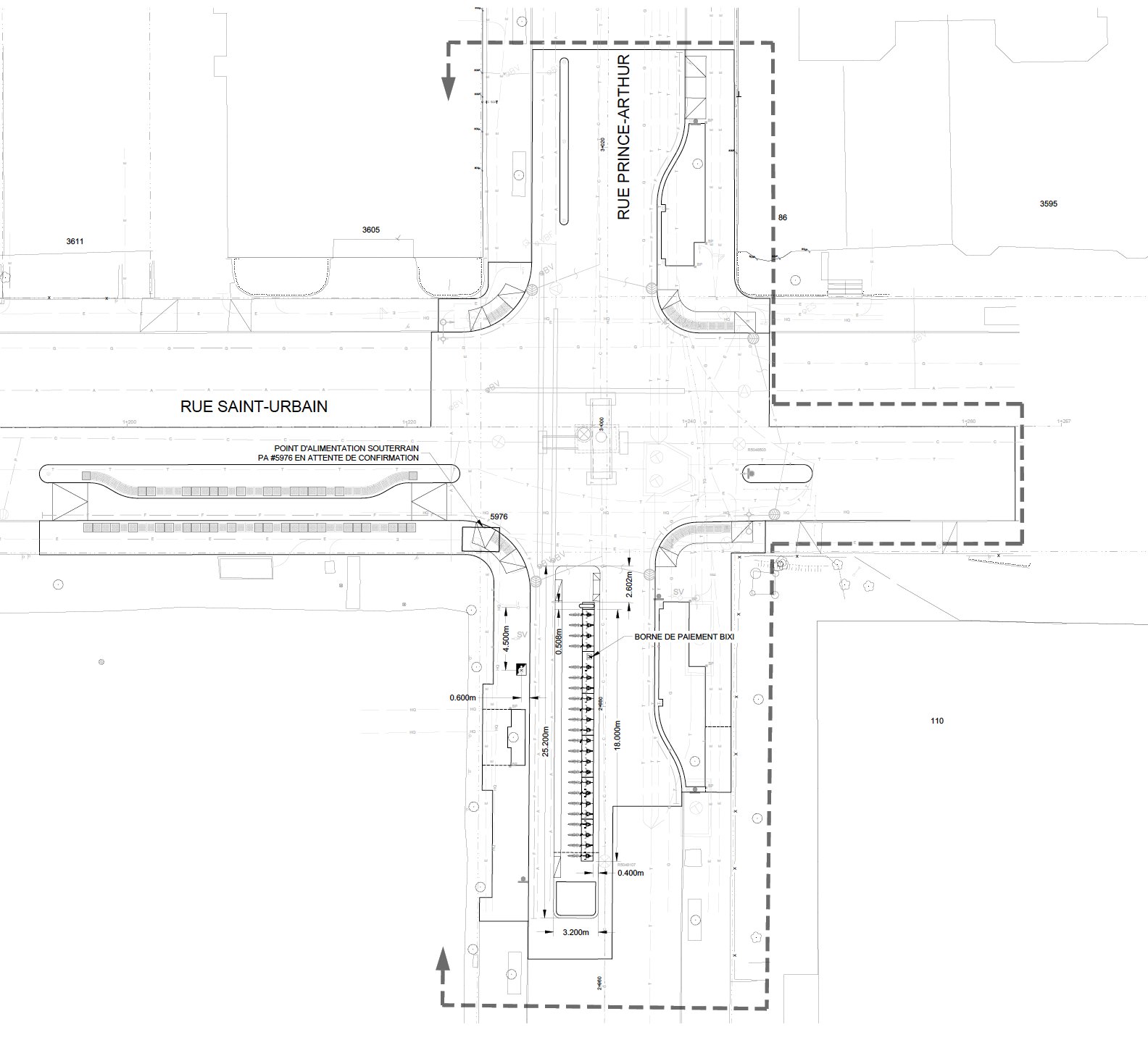
Prince-Arthur and Saint-Urbain intersection will become more protected for bikes, the bus stop will become raised on Saint-Urbain (like done elsewhere) and Bixi will have their own space raised from the road, giving a connection to the westbound bike path. This will be done after underground infrastructure work here in 2025
9 « J'aime »
Plusieurs projets de pistes cyclables dans Le Sud-Ouest, Verdun et Lachine
L’un des principaux projets dans le secteur en 2024 est la mise en place du Réseau Express Vélo (REV) Viger/Saint-Antoine/Saint-Jacques. On parle ici du développement des sections des rues Saint-Antoine Ouest et Saint-Jacques entre l’avenue Atwater et la rue Guy, ainsi que du développement de Saint-Antoine Ouest entre la rue De Courcelle et l’avenue Laporte et de la rue Saint-Jacques entre la rue De Courcelle et l’avenue Atwater.
Toujours dans Le Sud-Ouest, la Ville de Montréal procèdera à la mise à niveau et au développement de la piste cyclable sur la rue Hadley entre la rue de l’Église et le boulevard de la Vérendrye.
À Verdun, les pistes cyclables de la Rue de Verdun entre les rues Henri-Duhamel et Godin et de la rue Henri-Duhamel entre le parc Alfred-Sauvé et le boulevard LaSalle vont faire l’objet d’une mise à jour.
Pour Lachine, la piste cyclable des Berges (route 5) aura droit à une mise à niveau le long du boulevard Saint-Joseph, entre la 39e et la 42e avenue ainsi qu’entre la 51e et la 52e avenue.
« Nous ne nous contentons pas de répondre à la demande observée par les compteurs qui cumulent les données d’achalandage sur le réseau, nous encourageons aussi la mobilité active là où le vélo est moins utilisé, puisque, bien souvent, c’est faute de pistes sécuritaires », a déclaré Marianne Giguère, conseillère associée aux transports actifs au sein du comité exécutif de la Ville de Montréal, par voie de communiqué.
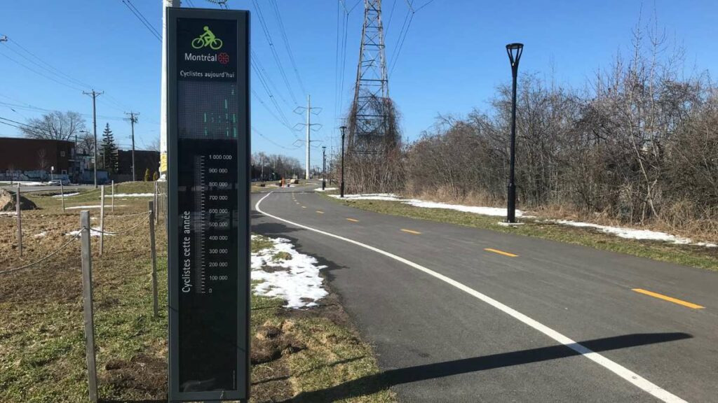
Aucun projet n’a été annoncé à LaSalle pour 2024. Mais, un nouveau tronçon de la piste de l’Aqueduc à partir de la 2e est déjà dans les plans depuis quelques mois.
Nouveau compteur à cyclistes sur la piste de l’Aqueduc à LaSalle (7 avril 2024) – Crédit photo : Karine Joly
3 « J'aime »
Communiqué de RPP
Côté mois positif, je suis aussi passé par William à Griffintown et la piste était encore bloquée de bout en bout. On en a déjà discuté ici, mais la configuration ne semble pas offrir l’espace requis pour la livraison et les automobilistes qui déposaient leurs passagers.
2 « J'aime »
Est-ce juste moi ou il y avait une piste cyclable sur Président-Kennedy avant et elle a disparu (à part un petit bout)?
7 « J'aime »
En effet.
Traverser le Centre-Ville est assez dangereux cet été. Piste de maisonneuve bloquée à la hauteur de Berri-Uqam, et de nouveau à McGill College pour le chantier du REM qui s’éternise.
1 « J'aime »
J’ai remarqué la même chose lundi. Ça ne faisait vraiment pas de mal d’avoir la piste sur President-Kennedy car l’état de Maisonneuve est horrible, il y a de la construction, de la circulation. C’était beaucoup plus agréable et je ne comprend vraiment pas l’intérêt de la retirer puisque la rue est inutilement large.
Je pense que ça fait qu’il n’y a aucune piste traversant le centre-ville d’est en ouest sans interruption? Vraiment décevent pour le centre-ville d’une métropole.
12 « J'aime »
oui j’ai déjà fait ma montée de lait là-dessus. Une aberration.
1 « J'aime »
On un donut à Montréal. Le centre-ville et les quartiers en périphéries sont très pauvres en réseau cyclable alors que les quartiers centraux sont beaucoup mieux. À la rigueur, je peux comprendre pour les quartiers en périphérie. Mais pour le centre-ville? ça me dépasse honnêtement. Manque de vision et de courage. C’est d’un ridicule.
14 « J'aime »
En même temps, seules quatre rues traversent d’est en ouest le plateau du centre-ville : Sherbrooke, de Maisonneuve, Sainte-Catherine et René-Lévesque (donc en excluant les voies en bas de la pente).
Il existe déjà une piste sur de Maisonneuve que la Ville doit détourner pendant l’été et la période des festivals. Sainte-Catherine sera, à terme, dédiée aux piétons.
Il reste Sherbrooke et René-Lévesque. On sait que René-Lévesque est identifié pour accueillir du transport collectif lourd et que la Ville souhaitait implanter des voies cyclables dans le cadre du REM de l’Est. Je parie que c’est toujours le cas, mais qu’ils attendent de déterminer ce qu’il adviendra de la rue avant.
Ce n’est pas comme si c’était simple de desservir le centre-ville…
REM de l’est? ![]()
1 « J'aime »